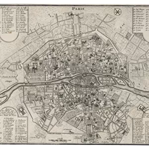
Metal Print : 1852, Levasseur Map of the Department De La Haute Loire, France, Loire Valley Region


![]()
Metal Prints From Liszt Collection
1852, Levasseur Map of the Department De La Haute Loire, France, Loire Valley Region
Liszt Collection of nineteenth-century engravings and images to browse and enjoy
Media ID 14005251
© Artokoloro Quint Lox Limited
1852 Antique Map Latitude Longitude Mappa Mundi Old Antique Plan Old Antique View Ols Antique Map Rare Old Maps Topo
16"x20" (51x41cm) Metal Print
Discover the rich history of the Loire Valley Region in France with our stunning Metal Print of the 1852 Levasseur Map of the Department De La Haute Loire. This intricately detailed antique map, part of the renowned Liszt Collection, transports you back in time with its captivating depiction of the region's geography. Our high-quality Metal Prints are known for their vibrant colors, sharp details, and long-lasting durability. Each print is meticulously crafted on a lightweight and waterproof aluminum sheet, ensuring a beautiful and sturdy display that is sure to be a conversation starter in any home or office. Bring a piece of historical cartography into your space and add an elegant touch to your decor with our 1852 Levasseur Map of the Department De La Haute Loire Metal Print.
Made with durable metal and luxurious printing techniques, our metal photo prints go beyond traditional canvases, adding a cool, modern touch to your space. Wall mount on back. Eco-friendly 100% post-consumer recycled ChromaLuxe aluminum surface. The thickness of the print is 0.045". Featuring a Scratch-resistant surface and Rounded corners. Backing hangers are attached to the back of the print and float the print 1/2-inch off the wall when hung, the choice of hanger may vary depending on size and International orders will come with Float Mount hangers only. Finished with a brilliant white high gloss surface for unsurpassed detail and vibrance. Printed using Dye-Sublimation and for best care we recommend a non-ammonia glass cleaner, water, or isopropyl (rubbing) alcohol to prevent harming the print surface. We recommend using a clean, lint-free cloth to wipe off the print. The ultra-hard surface is scratch-resistant, waterproof and weatherproof. Avoid direct sunlight exposure.
Made with durable metal and luxurious printing techniques, metal prints bring images to life and add a modern touch to any space
Estimated Image Size (if not cropped) is 50.8cm x 40.6cm (20" x 16")
Estimated Product Size is 51.4cm x 41.2cm (20.2" x 16.2")
These are individually made so all sizes are approximate
Artwork printed orientated as per the preview above, with landscape (horizontal) orientation to match the source image.
EDITORS COMMENTS
This print showcases the intricate details of the 1852 Levasseur Map of the Department De La Haute Loire in France's enchanting Loire Valley region. A true masterpiece of cartography, this vintage map offers a glimpse into a bygone era, where exploration and discovery were at the forefront of geographical understanding. The topography is meticulously depicted, with every contour and elevation carefully illustrated. The chart's grid lines reveal precise latitude and longitude coordinates, allowing for accurate navigation across this picturesque landscape. Its geometric design adds an artistic touch to its informative purpose. As we delve into history through this ancient map, we are transported back in time to witness the rich heritage and cultural significance of this region. The paper itself exudes an aged charm that further enhances its historical value. With its decorative elements and attention to detail, this rare old map serves as both a visual delight and a valuable educational resource. It invites us on a journey through time, inviting us to explore not only physical landscapes but also the stories embedded within them. Whether you are an avid traveler or simply appreciate artistry intertwined with geography, this Levasseur Map print from Liszt Collection is sure to captivate your imagination and spark curiosity about our world's past.
MADE IN THE USA
Safe Shipping with 30 Day Money Back Guarantee
FREE PERSONALISATION*
We are proud to offer a range of customisation features including Personalised Captions, Color Filters and Picture Zoom Tools
SECURE PAYMENTS
We happily accept a wide range of payment options so you can pay for the things you need in the way that is most convenient for you
* Options may vary by product and licensing agreement. Zoomed Pictures can be adjusted in the Basket.