Metal Print > Europe > United Kingdom > England > London > Sights > British Museum
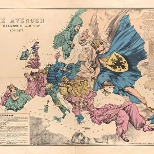
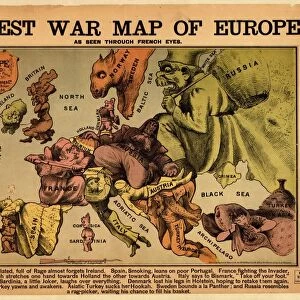
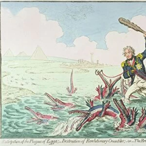
Metal Print : Serio-Comic War Map For The Year 1877, 1877


![]()
Metal Prints from Heritage Images
Serio-Comic War Map For The Year 1877, 1877
Serio-Comic War Map For The Year 1877, 1877. Found in the collection of State History Museum, Moscow
Heritage Images features heritage image collections
Media ID 15043436
© Fine Art Images
1877 1878 Balkan Balkan War Balkans Geopolitics Great Britain Ottoman Empire Ottomans Pan Slavism Panslavism Propaganda Russian Army Russian Troops Russo Turkish War Russo Turkish War 1877 1878 Colour Lithograph
16"x20" (51x41cm) Metal Print
Add a unique touch to your home or office decor with Media Storehouse's Metal Prints. This captivating Serio-Comic War Map for the Year 1877, 1877, sourced from the esteemed State History Museum in Moscow, Heritage Images, is now available in a metallic finish. The intricate details of this vintage map, with its humorous yet insightful representation of military conflicts, come alive when printed on high-quality metal. Each Metal Print is coated with a protective layer, ensuring durability and resistance to fading. Bring a piece of historical intrigue into your space and start a conversation with this one-of-a-kind wall art.
Made with durable metal and luxurious printing techniques, our metal photo prints go beyond traditional canvases, adding a cool, modern touch to your space. Wall mount on back. Eco-friendly 100% post-consumer recycled ChromaLuxe aluminum surface. The thickness of the print is 0.045". Featuring a Scratch-resistant surface and Rounded corners. Backing hangers are attached to the back of the print and float the print 1/2-inch off the wall when hung, the choice of hanger may vary depending on size and International orders will come with Float Mount hangers only. Finished with a brilliant white high gloss surface for unsurpassed detail and vibrance. Printed using Dye-Sublimation and for best care we recommend a non-ammonia glass cleaner, water, or isopropyl (rubbing) alcohol to prevent harming the print surface. We recommend using a clean, lint-free cloth to wipe off the print. The ultra-hard surface is scratch-resistant, waterproof and weatherproof. Avoid direct sunlight exposure.
Made with durable metal and luxurious printing techniques, metal prints bring images to life and add a modern touch to any space
Estimated Image Size (if not cropped) is 50.8cm x 40.6cm (20" x 16")
Estimated Product Size is 51.4cm x 41.2cm (20.2" x 16.2")
These are individually made so all sizes are approximate
Artwork printed orientated as per the preview above, with landscape (horizontal) orientation to match the source image.
FEATURES IN THESE COLLECTIONS
> Arts
> Pop art
> Satire
> Satirical artwork
> Asia
> Turkey
> Related Images
> Europe
> Related Images
> Europe
> Russia
> Related Images
> Europe
> United Kingdom
> England
> London
> Sights
> British Museum
> Maps and Charts
> British Empire Maps
> Maps and Charts
> Related Images
EDITORS COMMENTS
This print showcases the "Serio-Comic War Map For The Year 1877" created in 1877. Housed in the esteemed State History Museum in Moscow, this fine piece of graphic art offers a fascinating glimpse into history and geopolitics. The map, a vibrant colour lithograph, humorously depicts the Russo-Turkish War of 1877-1878 with great attention to detail. It cleverly satirizes various European powers involved in the conflict, including Great Britain and the Ottoman Empire. Panslavism and Pan-Slavic sentiments are also prominently featured. Created by Frederick William Rose (1849-1915), this work is an excellent example of European satirical maps from that era. Its purpose was undoubtedly to serve as propaganda during a time when tensions were high between Russia and Turkey. Through its intricate illustrations, it provides valuable insight into the military strategies employed by both Russian troops and their adversaries during this significant historical event. As a curiosity map, it not only captures one's attention but also invites viewers to delve deeper into understanding the complex dynamics at play during this period. This print serves as a testament to how art can be used as a powerful tool for political commentary and historical documentation.
MADE IN THE USA
Safe Shipping with 30 Day Money Back Guarantee
FREE PERSONALISATION*
We are proud to offer a range of customisation features including Personalised Captions, Color Filters and Picture Zoom Tools
SECURE PAYMENTS
We happily accept a wide range of payment options so you can pay for the things you need in the way that is most convenient for you
* Options may vary by product and licensing agreement. Zoomed Pictures can be adjusted in the Cart.