Metal Print > Africa > Angola > Maps
Metal Print : Map of Mid. And South Africa, 1919. Creator: George Philip & Son Ltd

![]()
Metal Prints From Heritage Images
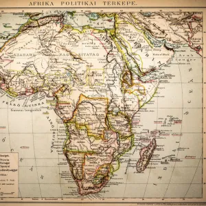
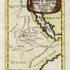
Map of Mid. And South Africa, 1919. Creator: George Philip & Son Ltd
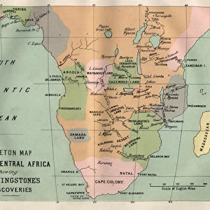
Map of Mid. And South Africa, 1919. Showing European possessions at outbreak of war, [the First World, 1914]. From " The History of the Great European War: its causes and effects", Vol. VIII, by W. Stanley Macbean Knight. [Caxton Pulishing Company, Limited, London, 1919]
Heritage Images features heritage image collections
Media ID 19047691
© The Print Collector/Heritage Images
Abyssinia And Son Ltd Angola Belgian Congo Cameroon Caxton Publishing Company Caxton Pulishing Company Caxton Pulishing Company Lim Caxton Pulishing Company Limited Caxton Pulishing Company Ltd Congo Ethiopia George Philip And Son George Philip And Son Ltd German Empire Imperial Imperialism Knight Limited Namibia Philip Portugal Portuguese Rhodesia South Africa Stanley Macbean Stanley Macbean Knight Sudan W Stanley Macbean W Stanley Macbean Knight William Stanley Macbean William Stanley Macbean Knight British Empire Cameroons German South West Africa
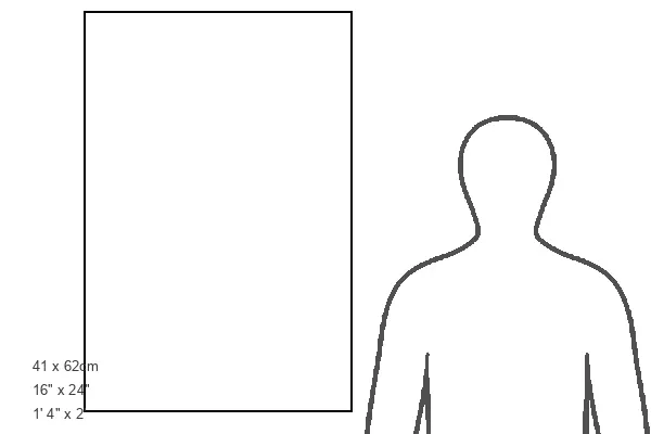
16"x24" (61x41cm) Metal Print
Discover history with our stunning Metal Print of a vintage Map of Mid. and South Africa from 1919. This captivating piece, created by George Philip & Son Ltd and sourced from Heritage Images, showcases European possessions at the outbreak of the First World War in 1914. Bring a piece of historical significance into your home or office with this high-quality Metal Print, featuring vivid colors and a sleek, modern design that adds depth and texture to any space. Relive the past and start a conversation with this unique and intriguing piece of art.
Made with durable metal and luxurious printing techniques, our metal photo prints go beyond traditional canvases, adding a cool, modern touch to your space. Wall mount on back. Eco-friendly 100% post-consumer recycled ChromaLuxe aluminum surface. The thickness of the print is 0.045". Featuring a Scratch-resistant surface and Rounded corners. Backing hangers are attached to the back of the print and float the print 1/2-inch off the wall when hung, the choice of hanger may vary depending on size and International orders will come with Float Mount hangers only. Finished with a brilliant white high gloss surface for unsurpassed detail and vibrance. Printed using Dye-Sublimation and for best care we recommend a non-ammonia glass cleaner, water, or isopropyl (rubbing) alcohol to prevent harming the print surface. We recommend using a clean, lint-free cloth to wipe off the print. The ultra-hard surface is scratch-resistant, waterproof and weatherproof. Avoid direct sunlight exposure.
Made with durable metal and luxurious printing techniques, metal prints bring images to life and add a modern touch to any space
Estimated Product Size is 41.2cm x 61.5cm (16.2" x 24.2")
These are individually made so all sizes are approximate
Artwork printed orientated as per the preview above, with portrait (vertical) orientation to match the source image.
FEATURES IN THESE COLLECTIONS
> Africa
> Angola
> Related Images
> Africa
> Cameroon
> Related Images
> Africa
> Ethiopia (Abyssinia)
> Maps
> Africa
> Ethiopia (Abyssinia)
> Related Images
> Africa
> Ethiopia
> Related Images
> Africa
> Namibia
> Related Images
> Africa
> South Africa
> Maps
EDITORS COMMENTS
This print showcases a detailed "Map of Mid. And South Africa, 1919" created by George Philip & Son Ltd. The map provides a fascinating glimpse into the European possessions in Africa at the outbreak of World War I in 1914. It was featured in Volume VIII of "The History of the Great European War: its causes and effects" by W. Stanley Macbean Knight, published by Caxton Publishing Company Limited in London. The map is richly colored, highlighting various countries and empires that held territories within Africa during this period. From British Empire colonies such as South Africa and Rhodesia to French Equatorial Africa and Portuguese holdings like Angola, it offers an insight into the vast imperial presence on the continent. Notably, German Empire's control over German South West Africa (present-day Namibia) can be observed alongside Abyssinia (Ethiopia), Sudan, Cameroon, Belgian Congo, and Italian territories. This visual representation underscores the extent of colonialism and imperialism prevalent during that era. With its historical significance and intricate details, this print serves as a valuable resource for researchers studying African history or anyone interested in exploring how political boundaries have evolved over time on the continent. Its preservation through Heritage Images ensures that future generations can appreciate this remarkable piece of cartographic artistry from early 20th-century Europe without commercial use implications mentioned explicitly by requesters.
MADE IN THE USA
Safe Shipping with 30 Day Money Back Guarantee
FREE PERSONALISATION*
We are proud to offer a range of customisation features including Personalised Captions, Color Filters and Picture Zoom Tools
SECURE PAYMENTS
We happily accept a wide range of payment options so you can pay for the things you need in the way that is most convenient for you
* Options may vary by product and licensing agreement. Zoomed Pictures can be adjusted in the Basket.