Metal Print > Europe > United Kingdom > Scotland > Edinburgh > Edinburgh
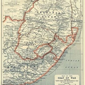
Metal Print : Map of the Boer Republics, 1900. Creator: Unknown

![]()
Metal Prints From Heritage Images
Map of the Boer Republics, 1900. Creator: Unknown
Map of the Boer Republics, 1900. From " South Africa and the Transvaal War, Vol. I", by Louis Creswicke. [T. C. & E. C. Jack, Edinburgh, 1900]
Heritage Images features heritage image collections
Media ID 19779063
© The Print Collector/Heritage Images
Boer Boers Cape Colony Cartography Creswicke Jack Louis Louis Creswicke Map Making Mapmaking Orange Free State Republic South Africa South Africa And The Transvaal War Tc And Ec Tc And Ec Jack Transvaal
16"x24" (61x41cm) Metal Print
Step back in time with our exquisite Metal Print of the Map of the Boer Republics, 1900. This historic map, sourced from "South Africa and the Transvaal War, Vol. I" by Louis Creswicke, showcases the political landscape of the Boer Republics during a pivotal moment in South African history. The intricate details of the map are brought to life through our premium Metal Print process, ensuring vibrant colors and exceptional clarity. Add a touch of history and sophistication to your space with this unique and captivating piece, created from an original image from Heritage Images.
Made with durable metal and luxurious printing techniques, our metal photo prints go beyond traditional canvases, adding a cool, modern touch to your space. Wall mount on back. Eco-friendly 100% post-consumer recycled ChromaLuxe aluminum surface. The thickness of the print is 0.045". Featuring a Scratch-resistant surface and Rounded corners. Backing hangers are attached to the back of the print and float the print 1/2-inch off the wall when hung, the choice of hanger may vary depending on size and International orders will come with Float Mount hangers only. Finished with a brilliant white high gloss surface for unsurpassed detail and vibrance. Printed using Dye-Sublimation and for best care we recommend a non-ammonia glass cleaner, water, or isopropyl (rubbing) alcohol to prevent harming the print surface. We recommend using a clean, lint-free cloth to wipe off the print. The ultra-hard surface is scratch-resistant, waterproof and weatherproof. Avoid direct sunlight exposure.
Made with durable metal and luxurious printing techniques, metal prints bring images to life and add a modern touch to any space
Estimated Product Size is 41.2cm x 61.5cm (16.2" x 24.2")
These are individually made so all sizes are approximate
Artwork printed orientated as per the preview above, with portrait (vertical) orientation to match the source image.
FEATURES IN THESE COLLECTIONS
> Africa
> South Africa
> Maps
> Africa
> South Africa
> Related Images
> Arts
> Literature
> Illustration
> Arts
> Literature
> Europe
> United Kingdom
> Scotland
> Edinburgh
> Edinburgh
> Europe
> United Kingdom
> Scotland
> Lothian
> Edinburgh
> Maps and Charts
> Related Images
EDITORS COMMENTS
This print showcases a historical treasure - the Map of the Boer Republics, 1900. Created by an unknown cartographer, this map is featured in Louis Creswicke's renowned book "South Africa and the Transvaal War, Vol. I". Published by T. C. & E. C. Jack in Edinburgh during 1900, this piece of art offers a fascinating glimpse into African geography and history. The map depicts the Boer Republics during the late 19th century, including significant locations such as South Africa, Transvaal Colony, Orange Free State, Cape Colony, and more. Its intricate details reveal not only the physical features of these regions but also their political boundaries and divisions at that time. As an illustration from a literary work on South African history and war narratives, this print holds immense cultural significance. It serves as a testament to the artistry involved in mapmaking during that era while providing valuable insights into colonial territories and conflicts. Preserved by The Print Collector organization for posterity's sake, this image reminds us of how maps have played an integral role in documenting our world throughout centuries. Whether used for navigation or understanding geopolitical landscapes, maps like these continue to captivate audiences with their beauty and historical value.
MADE IN THE USA
Safe Shipping with 30 Day Money Back Guarantee
FREE PERSONALISATION*
We are proud to offer a range of customisation features including Personalised Captions, Color Filters and Picture Zoom Tools
SECURE PAYMENTS
We happily accept a wide range of payment options so you can pay for the things you need in the way that is most convenient for you
* Options may vary by product and licensing agreement. Zoomed Pictures can be adjusted in the Basket.