Fine Art Print > Europe > United Kingdom > Scotland > Edinburgh > Edinburgh
Fine Art Print : Map of the Boer Republics, 1900. Creator: Unknown

![]()
Fine Art Prints From Heritage Images
Map of the Boer Republics, 1900. Creator: Unknown
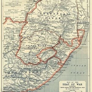
Map of the Boer Republics, 1900. From " South Africa and the Transvaal War, Vol. I", by Louis Creswicke. [T. C. & E. C. Jack, Edinburgh, 1900]
Heritage Images features heritage image collections
Media ID 19779063
© The Print Collector/Heritage Images
Boer Boers Cape Colony Cartography Creswicke Jack Louis Louis Creswicke Map Making Mapmaking Orange Free State Republic South Africa South Africa And The Transvaal War Tc And Ec Tc And Ec Jack Transvaal Transvaal Colony
21"x14" (+3" Border) Fine Art Print
Step back in time with our exquisite selection of Fine Art Prints from Media Storehouse. This captivating Map of the Boer Republics, 1900, showcases the political landscape during the Transvaal War. Originally published in "South Africa and the Transvaal War, Vol. I" by Louis Creswicke, this rare and intriguing map is now available as a beautiful Fine Art Print. The intricate details and rich history of this map are sure to make a striking addition to any home or office. Created from a high-resolution scan of an original image from Heritage Images, our Fine Art Prints are of the highest quality and are printed using archival inks and paper to ensure longevity. Bring a piece of history into your space with our Map of the Boer Republics, 1900 Fine Art Print.
21x14 image printed on 27x20 Fine Art Rag Paper with 3" (76mm) white border. Our Fine Art Prints are printed on 300gsm 100% acid free, PH neutral paper with archival properties. This printing method is used by museums and art collections to exhibit photographs and art reproductions.
Our fine art prints are high-quality prints made using a paper called Photo Rag. This 100% cotton rag fibre paper is known for its exceptional image sharpness, rich colors, and high level of detail, making it a popular choice for professional photographers and artists. Photo rag paper is our clear recommendation for a fine art paper print. If you can afford to spend more on a higher quality paper, then Photo Rag is our clear recommendation for a fine art paper print.
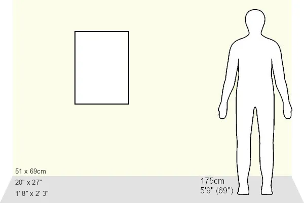
Estimated Image Size (if not cropped) is 35.5cm x 51.4cm (14" x 20.2")
Estimated Product Size is 50.8cm x 68.6cm (20" x 27")
These are individually made so all sizes are approximate
Artwork printed orientated as per the preview above, with portrait (vertical) orientation to match the source image.
FEATURES IN THESE COLLECTIONS
> Africa
> South Africa
> Maps
> Africa
> South Africa
> Related Images
> Arts
> Literature
> Illustration
> Arts
> Literature
> Europe
> United Kingdom
> Scotland
> Edinburgh
> Edinburgh
> Europe
> United Kingdom
> Scotland
> Lothian
> Edinburgh
> Maps and Charts
> Related Images
EDITORS COMMENTS
This print showcases a historical treasure - the Map of the Boer Republics, 1900. Created by an unknown cartographer, this map is featured in Louis Creswicke's renowned book "South Africa and the Transvaal War, Vol. I". Published by T. C. & E. C. Jack in Edinburgh during 1900, this piece of art offers a fascinating glimpse into African geography and history. The map depicts the Boer Republics during the late 19th century, including significant locations such as South Africa, Transvaal Colony, Orange Free State, Cape Colony, and more. Its intricate details reveal not only the physical features of these regions but also their political boundaries and divisions at that time. As an illustration from a literary work on South African history and war narratives, this print holds immense cultural significance. It serves as a testament to the artistry involved in mapmaking during that era while providing valuable insights into colonial territories and conflicts. Preserved by The Print Collector organization for posterity's sake, this image reminds us of how maps have played an integral role in documenting our world throughout centuries. Whether used for navigation or understanding geopolitical landscapes, maps like these continue to captivate audiences with their beauty and historical value.
MADE IN THE USA
Safe Shipping with 30 Day Money Back Guarantee
FREE PERSONALISATION*
We are proud to offer a range of customisation features including Personalised Captions, Color Filters and Picture Zoom Tools
SECURE PAYMENTS
We happily accept a wide range of payment options so you can pay for the things you need in the way that is most convenient for you
* Options may vary by product and licensing agreement. Zoomed Pictures can be adjusted in the Basket.