Metal Print > Northern renaissance paintings
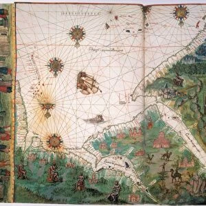
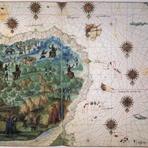
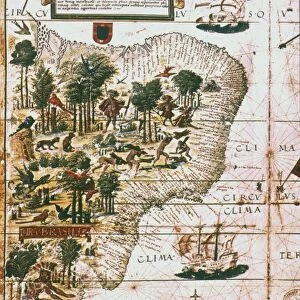
Metal Print : NEW WORLD MAP, 1547. Map of the West Indies and Central American from the Vallard Atlas


![]()
Metal Prints From Granger
NEW WORLD MAP, 1547. Map of the West Indies and Central American from the Vallard Atlas
NEW WORLD MAP, 1547. Map of the West Indies and Central American from the Vallard Atlas, c. 1547; the map, drawn " upside-down" as if viewed from Europe, shows Mexico City in the north and mining in northern South America
Granger holds millions of images spanning more than 25,000 years of world history, from before the Stone Age to the dawn of the Space Age
Media ID 6622385
1547 Age Of Discovery Caribbean Central Island Latin America Mesoamerica Mexico New World Portolan Chart Topography
16"x20" (51x41cm) Metal Print
Discover history with our stunning Metal Print of the New World Map from the Vallard Atlas, dating back to 1547. This captivating piece showcases the West Indies and Central America as they were explored during that era. The map, drawn "upside-down" as if viewed from Europe, adds an intriguing perspective to this historical artifact. Bring a piece of the past into your home or office with our high-quality Metal Print, which preserves the intricate details and vibrant colors of the original map. A perfect addition to any room, this unique and educational piece is sure to be a conversation starter.
Made with durable metal and luxurious printing techniques, our metal photo prints go beyond traditional canvases, adding a cool, modern touch to your space. Wall mount on back. Eco-friendly 100% post-consumer recycled ChromaLuxe aluminum surface. The thickness of the print is 0.045". Featuring a Scratch-resistant surface and Rounded corners. Backing hangers are attached to the back of the print and float the print 1/2-inch off the wall when hung, the choice of hanger may vary depending on size and International orders will come with Float Mount hangers only. Finished with a brilliant white high gloss surface for unsurpassed detail and vibrance. Printed using Dye-Sublimation and for best care we recommend a non-ammonia glass cleaner, water, or isopropyl (rubbing) alcohol to prevent harming the print surface. We recommend using a clean, lint-free cloth to wipe off the print. The ultra-hard surface is scratch-resistant, waterproof and weatherproof. Avoid direct sunlight exposure.
Made with durable metal and luxurious printing techniques, metal prints bring images to life and add a modern touch to any space
Estimated Image Size (if not cropped) is 50.8cm x 40.6cm (20" x 16")
Estimated Product Size is 51.4cm x 41.2cm (20.2" x 16.2")
These are individually made so all sizes are approximate
Artwork printed orientated as per the preview above, with landscape (horizontal) orientation to match the source image.
FEATURES IN THESE COLLECTIONS
> Granger Art on Demand
> Maps
> Arts
> Art Movements
> Renaissance Art
> Historic
> Renaissance art
> Northern Renaissance art
> Renaissance art
> Historic
> Renaissance art
> Northern Renaissance art
> Maps and Charts
> Related Images
> Maps and Charts
> World
> North America
> Mexico
> Mexico City
> North America
> Mexico
> Related Images
> Northern renaissance paintings
EDITORS COMMENTS
This print showcases a remarkable piece of history - the "NEW WORLD MAP, 1547". Taken from the Vallard Atlas, this map provides a unique perspective on the West Indies and Central America during the Renaissance era. What sets it apart is that it is drawn "upside-down" as if viewed from Europe. As we delve into this extraordinary artwork, our eyes are immediately drawn to Mexico City in the north. This bustling metropolis stands out amidst a sea of intricate details and vibrant colors. The map also highlights mining activities in northern South America, giving us a glimpse into the economic significance of these regions during that time. The topography depicted on this map offers an intriguing insight into how early cartographers perceived Latin America and its surrounding islands. It serves as a testament to their knowledge of geography during the Age of Discovery when explorers were venturing into uncharted territories. Through this image, we can appreciate not only the technical skill involved in creating such intricate maps but also gain an understanding of how Europeans visualized and understood distant lands centuries ago. It reminds us of their curiosity about new frontiers and their desire to document these discoveries for future generations. This Granger Collection print transports us back in time, allowing us to marvel at an important artifact from our collective past – a fascinating window into the New World's exploration and cultural exchange during one of history's most transformative periods.
MADE IN THE USA
Safe Shipping with 30 Day Money Back Guarantee
FREE PERSONALISATION*
We are proud to offer a range of customisation features including Personalised Captions, Color Filters and Picture Zoom Tools
SECURE PAYMENTS
We happily accept a wide range of payment options so you can pay for the things you need in the way that is most convenient for you
* Options may vary by product and licensing agreement. Zoomed Pictures can be adjusted in the Basket.