Metal Print > Arts > Artists > O > Oceanic Oceanic
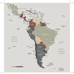
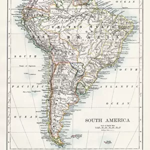
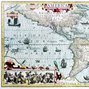
Metal Print : South America Map Illustration, Travel, Exploration, Antique 1871 Illustration


![]()
Metal Prints From Fine Art Storehouse
South America Map Illustration, Travel, Exploration, Antique 1871 Illustration
Color stock photo of an antique South America map illustration. Salvaged from an 1871 geography book
Unleash your creativity and transform your space into a visual masterpiece!
ideabug
Media ID 15387305
© ideabug
1870 1879 1871 Amazon Region Amazon River Atlantic Ocean Brazil Brown Chile Colombia Country Geographic Area Dirty Document Ecuador Education Exploration Geology Image Created 1870 1879 Latin American Culture Line Art Monoprint Pacific Ocean Page Paper Peru South America South American Culture Stained Topographic Map Topography Venezuela Green Color Image Created 19th Century
16"x20" (51x41cm) Metal Print
Discover the wonders of South America with our stunning Metal Prints from Media Storehouse. Each print features an exquisite antique illustration of a South America map from 1871, salvaged from a rare geography book. This vintage travel and exploration-themed map is sure to add a unique and captivating touch to any room in your home or office. Our high-quality Metal Prints are made using premium materials and state-of-the-art printing techniques, ensuring vibrant colors and sharp details that bring the past to life. Elevate your decor and transport yourself on a journey of discovery with our South America Map Illustration Metal Print from Fine Art Storehouse.
Made with durable metal and luxurious printing techniques, our metal photo prints go beyond traditional canvases, adding a cool, modern touch to your space. Wall mount on back. Eco-friendly 100% post-consumer recycled ChromaLuxe aluminum surface. The thickness of the print is 0.045". Featuring a Scratch-resistant surface and Rounded corners. Backing hangers are attached to the back of the print and float the print 1/2-inch off the wall when hung, the choice of hanger may vary depending on size and International orders will come with Float Mount hangers only. Finished with a brilliant white high gloss surface for unsurpassed detail and vibrance. Printed using Dye-Sublimation and for best care we recommend a non-ammonia glass cleaner, water, or isopropyl (rubbing) alcohol to prevent harming the print surface. We recommend using a clean, lint-free cloth to wipe off the print. The ultra-hard surface is scratch-resistant, waterproof and weatherproof. Avoid direct sunlight exposure.
Made with durable metal and luxurious printing techniques, metal prints bring images to life and add a modern touch to any space
Estimated Image Size (if not cropped) is 40.6cm x 50.8cm (16" x 20")
Estimated Product Size is 41.2cm x 51.4cm (16.2" x 20.2")
These are individually made so all sizes are approximate
Artwork printed orientated as per the preview above, with portrait (vertical) orientation to match the source image.
FEATURES IN THESE COLLECTIONS
> Arts
> Artists
> O
> Oceanic Oceanic
> Maps and Charts
> Geological Map
> Maps and Charts
> Related Images
> South America
> Brazil
> Maps
> South America
> Brazil
> Related Images
> South America
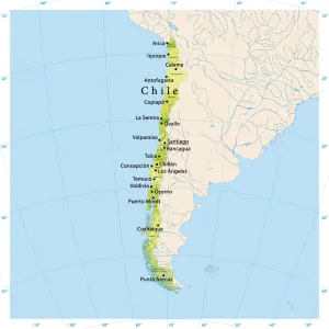
> Chile
> Maps
> South America
> Chile
> Related Images
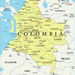
> South America
> Colombia
> Maps
EDITORS COMMENTS
This print showcases an exquisite South America map illustration, evoking a sense of adventure and exploration. Salvaged from an 1871 geography book, this antique piece takes us back to the enchanting world of the 19th century. The color stock photo beautifully captures the intricate details of this engraved image, created with meticulous etching techniques. The map reveals the diverse topography and physical geography of South America, stretching from the Pacific Ocean to the Atlantic Ocean. It highlights countries like Venezuela, Peru, Colombia, Chile, Brazil, and Ecuador while featuring prominent landmarks such as the Amazon River and its lush rainforests. With its green hues and brown stains on aged paper, this vintage artwork exudes a certain charm that transports us to a bygone era. Its worn appearance adds character and authenticity to any space it graces. Beyond its aesthetic appeal lies a rich historical significance. This document serves as both an educational tool and a testament to past cultures in Latin America. It invites viewers to delve into history while igniting wanderlust for travel enthusiasts who yearn to explore these fascinating destinations firsthand. Whether displayed in homes or offices alike, this South America map illustration is sure to captivate admirers with its timeless beauty and cultural importance.
MADE IN THE USA
Safe Shipping with 30 Day Money Back Guarantee
FREE PERSONALISATION*
We are proud to offer a range of customisation features including Personalised Captions, Color Filters and Picture Zoom Tools
SECURE PAYMENTS
We happily accept a wide range of payment options so you can pay for the things you need in the way that is most convenient for you
* Options may vary by product and licensing agreement. Zoomed Pictures can be adjusted in the Basket.