Metal Print > Maps and Charts > Related Images
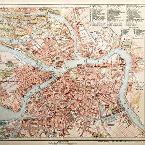
Metal Print : Map of Eurasia 1897


![]()
Metal Prints from Fine Art Storehouse
Map of Eurasia 1897
Natural Elementary Geography by Redway and Hinman - NY/Cincinnati/Chicago 1897
Unleash your creativity and transform your space into a visual masterpiece!
THEPALMER
Media ID 18356687
16"x20" (51x41cm) Metal Print
Discover the historical charm of the past with our Media Storehouse Metal Print featuring the Map of Eurasia 1897 by THEPALMER. This exquisite piece is taken from the classic geography book "Natural Elementary Geography" published by Redway and Hinman in 1897. The intricate details of the map are brought to life through our premium metal print process, which not only enhances the colors and contrast but also adds a modern and stylish touch to your decor. This timeless map is perfect for history enthusiasts, geography buffs, or anyone who appreciates the beauty of vintage maps. Hang it in your home, office, or as a unique gift to transport yourself back in time.
Made with durable metal and luxurious printing techniques, our metal photo prints go beyond traditional canvases, adding a cool, modern touch to your space. Wall mount on back. Eco-friendly 100% post-consumer recycled ChromaLuxe aluminum surface. The thickness of the print is 0.045". Featuring a Scratch-resistant surface and Rounded corners. Backing hangers are attached to the back of the print and float the print 1/2-inch off the wall when hung, the choice of hanger may vary depending on size and International orders will come with Float Mount hangers only. Finished with a brilliant white high gloss surface for unsurpassed detail and vibrance. Printed using Dye-Sublimation and for best care we recommend a non-ammonia glass cleaner, water, or isopropyl (rubbing) alcohol to prevent harming the print surface. We recommend using a clean, lint-free cloth to wipe off the print. The ultra-hard surface is scratch-resistant, waterproof and weatherproof. Avoid direct sunlight exposure.
Made with durable metal and luxurious printing techniques, metal prints bring images to life and add a modern touch to any space
Estimated Image Size (if not cropped) is 50.8cm x 40.6cm (20" x 16")
Estimated Product Size is 51.4cm x 41.2cm (20.2" x 16.2")
These are individually made so all sizes are approximate
Artwork printed orientated as per the preview above, with landscape (horizontal) orientation to match the source image.
FEATURES IN THESE COLLECTIONS
> Fine Art Storehouse
> Map
> Historical Maps
> Maps and Charts
> Related Images
EDITORS COMMENTS
In this print titled "Map of Eurasia 1897" we are transported back in time to the late 19th century, where cartography was a true art form. The map, originally featured in the renowned book "Natural Elementary Geography" by Redway and Hinman, takes us on a visual journey across the vast expanse of Eurasia. As our eyes explore every intricate detail meticulously etched onto this vintage masterpiece, we are reminded of an era when exploration and discovery were at their peak. The delicate lines trace the borders of countries long gone or transformed over time, offering a glimpse into the geopolitical landscape of that period. The craftsmanship is evident as we observe each city marked with precision and care. From bustling metropolises to remote villages nestled amidst breathtaking landscapes, this map encapsulates both human civilization and natural wonders within its borders. "The Map of Eurasia 1897" transports us beyond mere geography; it evokes a sense of nostalgia for an era when maps were cherished possessions that ignited curiosity and fueled dreams of far-off lands. Its historical significance lies not only in its accuracy but also in its ability to transport us back to a time when explorers embarked on daring adventures across unknown territories. This print by THEPALMER from Fine Art Storehouse serves as a reminder that even in today's digital age, there is still something magical about holding a physical representation of our world's history right before our eyes.
MADE IN THE USA
Safe Shipping with 30 Day Money Back Guarantee
FREE PERSONALISATION*
We are proud to offer a range of customisation features including Personalised Captions, Color Filters and Picture Zoom Tools
SECURE PAYMENTS
We happily accept a wide range of payment options so you can pay for the things you need in the way that is most convenient for you
* Options may vary by product and licensing agreement. Zoomed Pictures can be adjusted in the Cart.