Canvas Print > Maps and Charts > Related Images
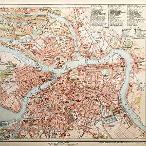
Canvas Print : Map of Eurasia 1897


![]()
Canvas Prints from Fine Art Storehouse
Map of Eurasia 1897
Natural Elementary Geography by Redway and Hinman - NY/Cincinnati/Chicago 1897
Unleash your creativity and transform your space into a visual masterpiece!
THEPALMER
Media ID 18356687
20"x16" (51x41cm) Canvas Print
Step back in time with our exquisite Canvas Print of the Map of Eurasia 1897 from ThePalmer, part of our Media Storehouse Fine Art Collection. This captivating vintage map, originally published in the classic geography book "Natural Elementary Geography" by Redway and Hinman in 1897, is now available in a stunning, high-quality canvas print. Perfect for adding a touch of history and character to your home or office, this canvas print showcases intricate cartography and detailed illustrations that transport you back to a bygone era. Each print is carefully crafted using premium materials and techniques to ensure lasting beauty and vibrancy. Bring the rich history of geography into your space with this unique and captivating addition to your decor.
Delivered stretched and ready to hang our premium quality canvas prints are made from a polyester/cotton blend canvas and stretched over a 1.25" (32mm) kiln dried knot free wood stretcher bar. Packaged in a plastic bag and secured to a cardboard insert for safe transit.
Canvas Prints add colour, depth and texture to any space. Professionally Stretched Canvas over a hidden Wooden Box Frame and Ready to Hang
Estimated Product Size is 50.8cm x 40.6cm (20" x 16")
These are individually made so all sizes are approximate
Artwork printed orientated as per the preview above, with landscape (horizontal) orientation to match the source image.
FEATURES IN THESE COLLECTIONS
> Maps and Charts
> Related Images
> Fine Art Storehouse
> Map
> Historical Maps
EDITORS COMMENTS
In this print titled "Map of Eurasia 1897" we are transported back in time to the late 19th century, where cartography was a true art form. The map, originally featured in the renowned book "Natural Elementary Geography" by Redway and Hinman, takes us on a visual journey across the vast expanse of Eurasia. As our eyes explore every intricate detail meticulously etched onto this vintage masterpiece, we are reminded of an era when exploration and discovery were at their peak. The delicate lines trace the borders of countries long gone or transformed over time, offering a glimpse into the geopolitical landscape of that period. The craftsmanship is evident as we observe each city marked with precision and care. From bustling metropolises to remote villages nestled amidst breathtaking landscapes, this map encapsulates both human civilization and natural wonders within its borders. "The Map of Eurasia 1897" transports us beyond mere geography; it evokes a sense of nostalgia for an era when maps were cherished possessions that ignited curiosity and fueled dreams of far-off lands. Its historical significance lies not only in its accuracy but also in its ability to transport us back to a time when explorers embarked on daring adventures across unknown territories. This print by THEPALMER from Fine Art Storehouse serves as a reminder that even in today's digital age, there is still something magical about holding a physical representation of our world's history right before our eyes.
MADE IN THE USA
Safe Shipping with 30 Day Money Back Guarantee
FREE PERSONALISATION*
We are proud to offer a range of customisation features including Personalised Captions, Color Filters and Picture Zoom Tools
SECURE PAYMENTS
We happily accept a wide range of payment options so you can pay for the things you need in the way that is most convenient for you
* Options may vary by product and licensing agreement. Zoomed Pictures can be adjusted in the Cart.