Metal Print > North America > United States of America > New York > New York > Maps
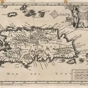
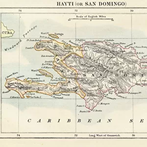
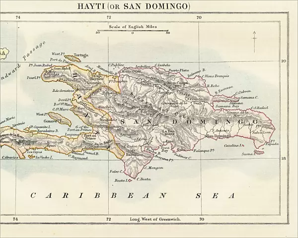
Metal Print : Haiti and Dominican republic map 1883


![]()
Metal Prints from Fine Art Storehouse
Haiti and Dominican republic map 1883
Encyclopedia Britannica 9th Edition New York Samuel L. Hall 1883 Vol XI
Unleash your creativity and transform your space into a visual masterpiece!
THEPALMER
Media ID 14756796
© This content is subject to copyright
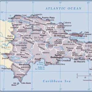
Caribbean Sea Haiti Island Santo Domingo
16"x20" (51x41cm) Metal Print
Transport yourself back in time with our stunning Metal Print of the Haiti and Dominican Republic map from THEPALMER's 1883 publication in the Encyclopedia Britannica 9th Edition. This vintage map, originally published in New York by Samuel L. Hall, showcases intricate detail and historical accuracy. Our high-quality Metal Print preserves the rich colors and textures of the original map, bringing a piece of history into your home or office. The sleek and modern metal finish adds a contemporary touch to this classic piece, making it a unique and thoughtful addition to any decor. Order now and step into the past with this beautiful and informative work of art.
Made with durable metal and luxurious printing techniques, our metal photo prints go beyond traditional canvases, adding a cool, modern touch to your space. Wall mount on back. Eco-friendly 100% post-consumer recycled ChromaLuxe aluminum surface. The thickness of the print is 0.045". Featuring a Scratch-resistant surface and Rounded corners. Backing hangers are attached to the back of the print and float the print 1/2-inch off the wall when hung, the choice of hanger may vary depending on size and International orders will come with Float Mount hangers only. Finished with a brilliant white high gloss surface for unsurpassed detail and vibrance. Printed using Dye-Sublimation and for best care we recommend a non-ammonia glass cleaner, water, or isopropyl (rubbing) alcohol to prevent harming the print surface. We recommend using a clean, lint-free cloth to wipe off the print. The ultra-hard surface is scratch-resistant, waterproof and weatherproof. Avoid direct sunlight exposure.
Made with durable metal and luxurious printing techniques, metal prints bring images to life and add a modern touch to any space
Estimated Image Size (if not cropped) is 50.8cm x 40.6cm (20" x 16")
Estimated Product Size is 51.4cm x 41.2cm (20.2" x 16.2")
These are individually made so all sizes are approximate
Artwork printed orientated as per the preview above, with landscape (horizontal) orientation to match the source image.
FEATURES IN THESE COLLECTIONS
> Fine Art Storehouse
> Map
> Historical Maps
> Maps and Charts
> Related Images
> North America
> Dominican Republic
> Dominican Republic Heritage Sites
> Colonial City of Santo Domingo
> North America
> Dominican Republic
> Maps
> North America
> Dominican Republic
> Related Images
> North America
> Dominican Republic
> Santo Domingo
> North America
> Haiti
> Maps
> North America
> Haiti
> Related Images
> North America
> United States of America
> New York
> New York
> Maps
> North America
> United States of America
> New York
> Related Images
EDITORS COMMENTS
In this print titled "Haiti and Dominican Republic Map 1883" we are transported back in time to the late 19th century, where cartography was a meticulous art form. This particular piece is sourced from the Encyclopedia Britannica's 9th Edition, published in New York by Samuel L. Hall in 1883. The map showcases the beautiful islands of Haiti and the Dominican Republic nestled within the Caribbean Sea. With intricate details and precise markings, it provides a fascinating glimpse into the geographical landscape of these two nations during that era. As we examine this vintage map, our eyes are drawn to Santo Domingo, an important city on Hispaniola Island that has witnessed centuries of history unfold. The delicate lines trace rivers, mountains, and coastlines with remarkable accuracy—reminding us of how early explorers navigated these lands without modern technology. This print by THEPALMER captures not only historical significance but also serves as a visual testament to human curiosity and exploration. It invites us to reflect upon how boundaries have shifted over time while appreciating the enduring beauty of these Caribbean nations. Whether displayed in a study or gallery space, this artwork transports viewers back to an age when maps were cherished artifacts representing knowledge and discovery. Through its rich historical context and artistic presentation, "Haiti and Dominican Republic Map 1883" offers both educational value and aesthetic appeal for admirers of fine art prints.
MADE IN THE USA
Safe Shipping with 30 Day Money Back Guarantee
FREE PERSONALISATION*
We are proud to offer a range of customisation features including Personalised Captions, Color Filters and Picture Zoom Tools
SECURE PAYMENTS
We happily accept a wide range of payment options so you can pay for the things you need in the way that is most convenient for you
* Options may vary by product and licensing agreement. Zoomed Pictures can be adjusted in the Cart.