Metal Print > North America > United States of America > New York > New York > Maps
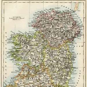
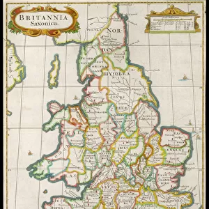
Metal Print : England and Wales map 1875


![]()
Metal Prints From Fine Art Storehouse
England and Wales map 1875
The Independent Course Comprehensive Geography by James Monteith, A.S. Barnes & Co, New York & Chicago 1875
Unleash your creativity and transform your space into a visual masterpiece!
THEPALMER
Media ID 13612251
© This content is subject to copyright
Globe Navigational Equipment Paper Wales
16"x20" (51x41cm) Metal Print
Step back in time with our exquisite Metal Print of the England and Wales map from 1875, meticulously reproduced from the classic geography book "The Independent Course in Geography" by James Monteith. This vintage map, sourced from THEPALMER's Fine Art Storehouse, showcases intricate detail and historical accuracy. The high-quality metal print adds a unique, contemporary twist to this antique cartographic masterpiece, making it a stunning addition to any home or office decor. Bring history to life with this captivating piece of art.
Made with durable metal and luxurious printing techniques, our metal photo prints go beyond traditional canvases, adding a cool, modern touch to your space. Wall mount on back. Eco-friendly 100% post-consumer recycled ChromaLuxe aluminum surface. The thickness of the print is 0.045". Featuring a Scratch-resistant surface and Rounded corners. Backing hangers are attached to the back of the print and float the print 1/2-inch off the wall when hung, the choice of hanger may vary depending on size and International orders will come with Float Mount hangers only. Finished with a brilliant white high gloss surface for unsurpassed detail and vibrance. Printed using Dye-Sublimation and for best care we recommend a non-ammonia glass cleaner, water, or isopropyl (rubbing) alcohol to prevent harming the print surface. We recommend using a clean, lint-free cloth to wipe off the print. The ultra-hard surface is scratch-resistant, waterproof and weatherproof. Avoid direct sunlight exposure.
Made with durable metal and luxurious printing techniques, metal prints bring images to life and add a modern touch to any space
Estimated Image Size (if not cropped) is 40.6cm x 50.8cm (16" x 20")
Estimated Product Size is 41.2cm x 51.4cm (16.2" x 20.2")
These are individually made so all sizes are approximate
Artwork printed orientated as per the preview above, with portrait (vertical) orientation to match the source image.
FEATURES IN THESE COLLECTIONS
> Fine Art Storehouse
> The Magical World of Illustration
> Palmer Illustrated Collection
> Fine Art Storehouse
> Map
> Historical Maps
> Fine Art Storehouse
> Map
> USA Maps
> Europe
> United Kingdom
> England
> Maps
> Europe
> United Kingdom
> England
> York
> Europe
> United Kingdom
> Maps
> Europe
> United Kingdom
> Wales
> Maps
> Europe
> United Kingdom
> Wales
> Posters
> Europe
> United Kingdom
> Wales
> Related Images
> Maps and Charts
> Related Images
> Maps and Charts
> Wales
> North America
> United States of America
> Maps
> North America
> United States of America
> New York
> New York
> Maps
EDITORS COMMENTS
This print showcases a remarkable piece of history, the "England and Wales map 1875" from James Monteith's renowned publication, "The Independent Course Comprehensive Geography". Published by A. S. Barnes & Co in New York and Chicago in 1875, this antique engraving provides a fascinating glimpse into the cartography of that era. The intricately detailed illustration captures the physical geography of England and Wales with utmost precision. Every contour, river, mountain range, and city is meticulously etched onto paper to create an exquisite visual representation. The craftsmanship involved in creating this engraved image is truly commendable. As we gaze upon this vertical masterpiece, our eyes are drawn to the fine details that bring these lands to life. The delicate lines depict not only geographical features but also evoke a sense of nostalgia for a time long gone. This vintage map serves as a window into the past when navigational equipment was still evolving and globe exploration was at its peak. "The Independent Course Comprehensive Geography" holds immense historical significance as it played an instrumental role in educating generations about the world around them during its time. Now preserved through this stunning print by THEPALMER from Fine Art Storehouse, it allows us to appreciate both its artistic beauty and educational value. Whether you have an affinity for old-world charm or simply admire intricate cartography, this enchanting artwork transports you back to 1875 England and Wales while serving as a testament to human curiosity and exploration throughout history.
MADE IN THE USA
Safe Shipping with 30 Day Money Back Guarantee
FREE PERSONALISATION*
We are proud to offer a range of customisation features including Personalised Captions, Color Filters and Picture Zoom Tools
SECURE PAYMENTS
We happily accept a wide range of payment options so you can pay for the things you need in the way that is most convenient for you
* Options may vary by product and licensing agreement. Zoomed Pictures can be adjusted in the Basket.