Metal Print > North America > Cuba > Cuba Heritage Sites > Old Havana and its Fortification System
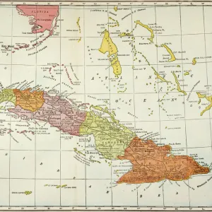
Metal Print : Geography: Map of Puerto Rico Island in the Caribbean with descriptive text. Map from an Atlas of Geopolitics from 1851. Biblioteca Jose Marti, Havana, Cuba


![]()
Metal Prints From Fine Art Finder
Geography: Map of Puerto Rico Island in the Caribbean with descriptive text. Map from an Atlas of Geopolitics from 1851. Biblioteca Jose Marti, Havana, Cuba
VEN5031321 Geography: Map of Puerto Rico Island in the Caribbean with descriptive text. Map from an Atlas of Geopolitics from 1851. Biblioteca Jose Marti, Havana, Cuba; (add.info.: Geography: Map of Puerto Rico Island in the Caribbean with descriptive text. Map from an Atlas of Geopolitics from 1851. Biblioteca Jose Marti, Havana, Cuba); © Marage Photos
Media ID 38164394
© © Marage Photos / Bridgeman Images
Amerique Centrale Amerique Du Nord Caraïbes Caribbean Caribbean Island Carte Geographique Central America Etats Unis Geographie Stockravenna 18eme Siecle Geographical Map
16"x24" (61x41cm) Metal Print
"Explore the beauty of Puerto Rico's rich history with our stunning Metal Prints from Media Storehouse! This vintage map, dating back to 1851, showcases the island's geography in exquisite detail. Printed on high-quality metal for a modern and sleek finish, this unique piece is perfect for any room in your home or office. The intricate design and historical significance make it a must-have for anyone fascinated by geography, travel, or antique maps. Bring a touch of nostalgia and adventure to your space with this beautiful Metal Print from Media Storehouse."
Made with durable metal and luxurious printing techniques, our metal photo prints go beyond traditional canvases, adding a cool, modern touch to your space. Wall mount on back. Eco-friendly 100% post-consumer recycled ChromaLuxe aluminum surface. The thickness of the print is 0.045". Featuring a Scratch-resistant surface and Rounded corners. Backing hangers are attached to the back of the print and float the print 1/2-inch off the wall when hung, the choice of hanger may vary depending on size and International orders will come with Float Mount hangers only. Finished with a brilliant white high gloss surface for unsurpassed detail and vibrance. Printed using Dye-Sublimation and for best care we recommend a non-ammonia glass cleaner, water, or isopropyl (rubbing) alcohol to prevent harming the print surface. We recommend using a clean, lint-free cloth to wipe off the print. The ultra-hard surface is scratch-resistant, waterproof and weatherproof. Avoid direct sunlight exposure.
Made with durable metal and luxurious printing techniques, metal prints bring images to life and add a modern touch to any space
Estimated Product Size is 61.5cm x 41.2cm (24.2" x 16.2")
These are individually made so all sizes are approximate
Artwork printed orientated as per the preview above, with landscape (horizontal) orientation to match the source image.
FEATURES IN THESE COLLECTIONS
> Maps and Charts
> Early Maps
> Maps and Charts
> Related Images
> North America
> Cuba
> Cuba Heritage Sites
> Old Havana and its Fortification System
> North America
> Cuba
> Havana
> North America
> Cuba
> Maps
> North America
> Cuba
> Related Images
> North America
> Puerto Rico
> Maps
> North America
> Puerto Rico
> Related Images
> North America
> United States of America
> Maps
EDITORS COMMENTS
This print showcases a Geography: Map of Puerto Rico Island in the Caribbean, dating back to 1851. The intricate details and historical significance of this map are truly remarkable, offering a glimpse into the past and providing valuable insights into the geographical landscape of Puerto Rico during that time period.
Displayed at Biblioteca Jose Marti in Havana, Cuba, this map is a true treasure from an Atlas of Geopolitics from the 18th century. Its engravings depict not only the physical features of the island but also include descriptive text that adds depth and context to its representation.
As you study this map closely, you can't help but be transported back in time to an era when cartography was both an art form and a scientific endeavor. The precision with which each detail is rendered speaks to the dedication and skill of those who created it.
Whether you have a personal connection to Puerto Rico or simply appreciate historical maps, this print is sure to captivate your imagination and spark your curiosity about the rich history of this beautiful Caribbean island. It serves as a reminder of how geography has shaped our world throughout centuries past.
MADE IN THE USA
Safe Shipping with 30 Day Money Back Guarantee
FREE PERSONALISATION*
We are proud to offer a range of customisation features including Personalised Captions, Color Filters and Picture Zoom Tools
SECURE PAYMENTS
We happily accept a wide range of payment options so you can pay for the things you need in the way that is most convenient for you
* Options may vary by product and licensing agreement. Zoomed Pictures can be adjusted in the Basket.