Metal Print > Maps and Charts > World
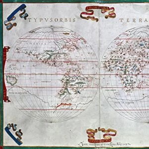
Metal Print : Universal Geographic Map (World Map) of 1596. Engraving. Private collection
 of 1596. Engraving. Private collection")

![]()
Metal Prints From Fine Art Finder
Universal Geographic Map (World Map) of 1596. Engraving. Private collection
JLJ4659302 Universal Geographic Map (World Map) of 1596. Engraving. Private collection. by Unknown Artist, (16th century); Private Collection; (add.info.: Universal Geographic Map (World Map) of 1596. Engraving. Private collection.); Photo ePhoto Josse; out of copyright
Media ID 22466148
© Josse / Bridgeman Images
Earth Planisphere Geographical Map
16"x20" (51x41cm) Metal Print
Discover the wonders of the past with our Media Storehouse Metal Prints featuring the exquisite Universal Geographic Map of 1596. This stunning engraving, from a private collection and available exclusively through Media Storehouse, showcases an intricately detailed world map created in the 16th century. The vintage charm of this rare and historic piece is brought to life through our premium metal print technology, ensuring a vibrant and long-lasting display. Add an air of sophistication and historical intrigue to any room with this unique and captivating work of art.
Made with durable metal and luxurious printing techniques, our metal photo prints go beyond traditional canvases, adding a cool, modern touch to your space. Wall mount on back. Eco-friendly 100% post-consumer recycled ChromaLuxe aluminum surface. The thickness of the print is 0.045". Featuring a Scratch-resistant surface and Rounded corners. Backing hangers are attached to the back of the print and float the print 1/2-inch off the wall when hung, the choice of hanger may vary depending on size and International orders will come with Float Mount hangers only. Finished with a brilliant white high gloss surface for unsurpassed detail and vibrance. Printed using Dye-Sublimation and for best care we recommend a non-ammonia glass cleaner, water, or isopropyl (rubbing) alcohol to prevent harming the print surface. We recommend using a clean, lint-free cloth to wipe off the print. The ultra-hard surface is scratch-resistant, waterproof and weatherproof. Avoid direct sunlight exposure.
Made with durable metal and luxurious printing techniques, metal prints bring images to life and add a modern touch to any space
Estimated Image Size (if not cropped) is 50.8cm x 40.6cm (20" x 16")
Estimated Product Size is 51.4cm x 41.2cm (20.2" x 16.2")
These are individually made so all sizes are approximate
Artwork printed orientated as per the preview above, with landscape (horizontal) orientation to match the source image.
FEATURES IN THESE COLLECTIONS
> Maps and Charts
> Related Images
> Maps and Charts
> World
EDITORS COMMENTS
This print showcases the Universal Geographic Map (World Map) of 1596, an exquisite engraving from a private collection. Created by an unknown artist in the 16th century, this intricate map offers a glimpse into the world as it was perceived centuries ago. The level of detail and precision in this engraving is truly remarkable. Every contour, coastline, and country is meticulously depicted, providing viewers with a comprehensive understanding of global geography during that era. The planisphere design allows for easy navigation across continents and oceans, making it an invaluable tool for explorers and scholars alike. As we gaze upon this ancient cartographic masterpiece, we are transported back in time to an age when our knowledge of the world was still expanding. It serves as a reminder of how far humanity has come in unraveling the mysteries of our planet. Preserved within a private collection, this rare artifact holds immense historical significance. Its presence evokes curiosity about the minds behind its creation and their perception of distant lands beyond their own horizons. Thanks to Photo Josse's expert photography skills, we can now appreciate every intricate detail of this engraving up close. This print not only captures the essence of this timeless artwork but also preserves it for future generations to admire and study.
MADE IN THE USA
Safe Shipping with 30 Day Money Back Guarantee
FREE PERSONALISATION*
We are proud to offer a range of customisation features including Personalised Captions, Color Filters and Picture Zoom Tools
SECURE PAYMENTS
We happily accept a wide range of payment options so you can pay for the things you need in the way that is most convenient for you
* Options may vary by product and licensing agreement. Zoomed Pictures can be adjusted in the Basket.