Metal Print > Africa > Zambia > Maps
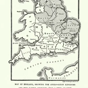
Metal Print : Zambia. An early map of Rhodesia and Nyasaland with antiques


![]()
Metal Prints from Discover Images by AWL
Zambia. An early map of Rhodesia and Nyasaland with antiques
Discover Images by AWL is a world-leading brand of premium quality travel images
Media ID 1646079
© John Warburton-Lee
Antique Antiques Binoculars Chiawa Camp Empire Exploration Lower Zambesi National Park Lower Zambezi National Park Nyasaland Rhodesia Victorian Zambia British Empire Looking Glass Magnifying Glass
16"x20" (51x41cm) Metal Print
Step back in time with our stunning Zambia Metal Print from Media Storehouse. This unique piece features an early map of Rhodesia and Nyasaland, a historical representation of the region's borders before Zambia's independence. The map is beautifully accompanied by antique elements from JWL's collection at Discover Images by AWL. Each Metal Print is meticulously crafted with a durable, high-gloss finish that brings out the intricate details of the map and antiques. Hang it in your home or office to add a touch of history and sophistication to your space. Order yours today and travel through time with every glance.
Made with durable metal and luxurious printing techniques, our metal photo prints go beyond traditional canvases, adding a cool, modern touch to your space. Wall mount on back. Eco-friendly 100% post-consumer recycled ChromaLuxe aluminum surface. The thickness of the print is 0.045". Featuring a Scratch-resistant surface and Rounded corners. Backing hangers are attached to the back of the print and float the print 1/2-inch off the wall when hung, the choice of hanger may vary depending on size and International orders will come with Float Mount hangers only. Finished with a brilliant white high gloss surface for unsurpassed detail and vibrance. Printed using Dye-Sublimation and for best care we recommend a non-ammonia glass cleaner, water, or isopropyl (rubbing) alcohol to prevent harming the print surface. We recommend using a clean, lint-free cloth to wipe off the print. The ultra-hard surface is scratch-resistant, waterproof and weatherproof. Avoid direct sunlight exposure.
Made with durable metal and luxurious printing techniques, metal prints bring images to life and add a modern touch to any space
Estimated Image Size (if not cropped) is 50.8cm x 40.6cm (20" x 16")
Estimated Product Size is 51.4cm x 41.2cm (20.2" x 16.2")
These are individually made so all sizes are approximate
Artwork printed orientated as per the preview above, with landscape (horizontal) orientation to match the source image.
FEATURES IN THESE COLLECTIONS
> Africa
> Related Images
> Africa
> Zambia
> Related Images
> Africa
> Zimbabwe
> Rhodesia
> Maps and Charts
> British Empire Maps
> Maps and Charts
> Early Maps
> Maps and Charts
> Related Images
EDITORS COMMENTS
This print takes us back in time to the historic era of Victorian exploration in Africa. The image showcases an early map of Rhodesia and Nyasaland, now known as Zambia, adorned with a collection of intriguing antiques. As we gaze upon this snapshot from history, we are transported to a bygone age filled with wonder and curiosity. The map itself is a testament to the British Empire's influence on the African continent during that period. It represents not only geographical boundaries but also the spirit of adventure and discovery that characterized this era. With its intricate details and faded colors, it invites us to delve into the past and imagine what life was like for those intrepid explorers who ventured into uncharted territories. Intriguingly, placed alongside the map are various antiques that further enhance our sense of nostalgia. A magnifying glass beckons us to examine every minute detail while binoculars hint at distant horizons waiting to be explored. These artifacts serve as tangible reminders of a time when Africa held untold mysteries and boundless possibilities. As we admire this remarkable composition captured by JWL, our imagination is ignited with thoughts of expeditions through vast wildernesses such as Lower Zambezi National Park or Chiawa Camp. This photograph encapsulates not just a moment frozen in time but also an entire chapter in African history - one defined by exploration, adventure, and the enduring allure of antique treasures from days gone by.
MADE IN THE USA
Safe Shipping with 30 Day Money Back Guarantee
FREE PERSONALISATION*
We are proud to offer a range of customisation features including Personalised Captions, Color Filters and Picture Zoom Tools
SECURE PAYMENTS
We happily accept a wide range of payment options so you can pay for the things you need in the way that is most convenient for you
* Options may vary by product and licensing agreement. Zoomed Pictures can be adjusted in the Cart.