Metal Print > North America > Puerto Rico > Maps
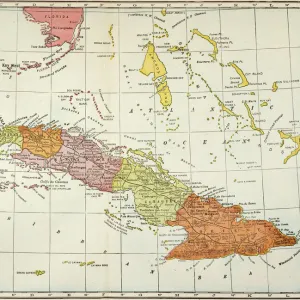
Metal Print : 18th century map of Central America and the Gulf of Mexico engraved by Balthasar Ruyter


![]()
Metal Prints From Design Pics
18th century map of Central America and the Gulf of Mexico engraved by Balthasar Ruyter
Design Pics offers Distinctively Different Imagery representing over 1,500 contributors
Media ID 24903269
© Ken Welsh / Design Pics
18th Century Central America Cuba Florida Geographical Geography Gulf Of Mexico Islands Jamaica Venezuela Hispaniola Puerto Rico
16"x24" (61x41cm) Metal Print
Transport yourself back in time with our stunning Media Storehouse Metal Print featuring an 18th century map of Central America and the Gulf of Mexico. This intricately detailed map, engraved by Balthasar Ruyter, offers a captivating glimpse into the history of the New World. The metal print's vibrant colors and high-definition image are sure to bring this historical artifact to life in your home or office. With its sleek, modern design and durable metal construction, this print is not only a beautiful addition to any space, but also a timeless investment in history.
Made with durable metal and luxurious printing techniques, our metal photo prints go beyond traditional canvases, adding a cool, modern touch to your space. Wall mount on back. Eco-friendly 100% post-consumer recycled ChromaLuxe aluminum surface. The thickness of the print is 0.045". Featuring a Scratch-resistant surface and Rounded corners. Backing hangers are attached to the back of the print and float the print 1/2-inch off the wall when hung, the choice of hanger may vary depending on size and International orders will come with Float Mount hangers only. Finished with a brilliant white high gloss surface for unsurpassed detail and vibrance. Printed using Dye-Sublimation and for best care we recommend a non-ammonia glass cleaner, water, or isopropyl (rubbing) alcohol to prevent harming the print surface. We recommend using a clean, lint-free cloth to wipe off the print. The ultra-hard surface is scratch-resistant, waterproof and weatherproof. Avoid direct sunlight exposure.
Made with durable metal and luxurious printing techniques, metal prints bring images to life and add a modern touch to any space
Estimated Product Size is 61.5cm x 41.2cm (24.2" x 16.2")
These are individually made so all sizes are approximate
Artwork printed orientated as per the preview above, with landscape (horizontal) orientation to match the source image.
FEATURES IN THESE COLLECTIONS
> Maps and Charts
> Early Maps
> North America
> Cuba
> Maps
> North America
> Cuba
> Related Images
> North America
> Jamaica
> Maps
> North America
> Jamaica
> Related Images
> North America
> Mexico
> Maps
> North America
> Mexico
> Related Images
> North America
> Puerto Rico
> Maps
> North America
> Puerto Rico
> Related Images
EDITORS COMMENTS
This vibrant and meticulously detailed 18th-century map of Central America and the Gulf of Mexico, engraved by Balthasar Ruyter, is a captivating piece that transports us back in time. The rich colors and intricate illustrations bring to life the geographical wonders and historical significance of this region. As we explore the map, our eyes are drawn to Cuba, an island steeped in culture and history. Its unique shape stands out amidst a sea of smaller islands scattered throughout the Gulf of Mexico. To its east lies Hispaniola, home to both Haiti and the Dominican Republic. Further south, we encounter Puerto Rico with its distinctive outline. Moving westward, we find Jamaica – known for its lush landscapes and reggae rhythms. Venezuela's northern coast stretches across the bottom edge of this remarkable depiction. The inclusion of Florida reminds us that even during this era, it held strategic importance as a gateway between North America and these tropical lands further south. This archival print serves not only as a beautiful decorative piece but also as a valuable resource for historians and geographers alike. It allows us to delve into centuries-old cartography techniques while appreciating how knowledge about these regions has evolved over time. Whether you have an interest in history or simply appreciate stunning artwork, this 18th-century map will undoubtedly captivate your imagination with its vivid colors, attention to detail, and glimpse into our world's past.
MADE IN THE USA
Safe Shipping with 30 Day Money Back Guarantee
FREE PERSONALISATION*
We are proud to offer a range of customisation features including Personalised Captions, Color Filters and Picture Zoom Tools
SECURE PAYMENTS
We happily accept a wide range of payment options so you can pay for the things you need in the way that is most convenient for you
* Options may vary by product and licensing agreement. Zoomed Pictures can be adjusted in the Basket.