Home > Europe > United Kingdom > England > London > Transport > Underground
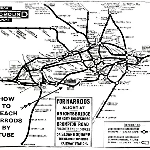
Map of the London Underground Railway System

![]()
Wall Art and Photo Gifts from Mary Evans Picture Library
Map of the London Underground Railway System
Map of the London Underground Railway System Date: 1909
Mary Evans Picture Library makes available wonderful images created for people to enjoy over the centuries
Media ID 32247508
© Mary Evans Picture Library
Maps Railways Route System Tube
FEATURES IN THESE COLLECTIONS
> Arts
> Literature
> Magazines
> Europe
> United Kingdom
> England
> London
> Transport
> Underground
> Maps and Charts
> Related Images
> Mary Evans Prints Online
> New Images July 2023
EDITORS COMMENTS
Step into the past with this 1909 Map of the London Underground Railway System, a fascinating glimpse into the evolution of transportation in the heart of the city. This intricately detailed map, brought to you by the magic of photography, invites us to explore the labyrinthine network of tubes and trains that have connected London's diverse neighborhoods for over a century. The map, produced in 1909, showcases the Central London Railway, also known as the "Tube," which had been in operation since 1863. By this time, the system had expanded significantly, with multiple lines crisscrossing beneath the city streets. The map's vibrant colors and clear, easy-to-read labels reveal the various routes and stations, offering a tantalizing glimpse into the Edwardian era. As we delve deeper into the map, we can see the Central Line in its infancy, with branches extending from Shepherd's Bush to Ealing and Hackney Wick to Woodford. The Northern and Piccadilly lines are also well-represented, connecting areas such as Edgware Road, King's Cross, and Hammersmith. This map serves as an essential historical record of London's transport system during the 1900s. It not only illustrates the growth and expansion of the Underground but also offers a captivating glimpse into the city's past. Imagine the excitement of early commuters as they navigated this new, underground world, connecting them to their workplaces, homes, and loved ones. As you gaze upon this beautiful print, you'll be transported back in time, immersed in the sights, sounds, and stories of London's rich history. A must-have for history buffs, transport enthusiasts, and anyone with a love for the city, this 1909 Map of the London Underground Railway System is a captivating addition to any home or office.
MADE IN THE USA
Safe Shipping with 30 Day Money Back Guarantee
FREE PERSONALISATION*
We are proud to offer a range of customisation features including Personalised Captions, Color Filters and Picture Zoom Tools
SECURE PAYMENTS
We happily accept a wide range of payment options so you can pay for the things you need in the way that is most convenient for you
* Options may vary by product and licensing agreement. Zoomed Pictures can be adjusted in the Cart.