Home > Europe > Spain > Maps
Atlas Novus, 17th c Planet Mercury
![]()

Wall Art and Photo Gifts from Mary Evans Picture Library
Atlas Novus, 17th c Planet Mercury
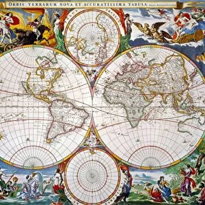
BLAEU, Jan (1596-1673). Atlas Novus or Atlas Maior. 1635 - 1665. Nova totius terrarum orbis geographica ac hydrographica tabula. Detail depicting and allegory of Mercury. Worldmap printed in Amsterdam circa 1635. Etching. SPAIN. CATALONIA. Barcelona. Biblioteca de Catalunya (National Library of Catalonia)
Mary Evans Picture Library makes available wonderful images created for people to enjoy over the centuries
Media ID 14179460
© Iberfoto/Mary Evans
1571 1596 1635 1638 1665 1673 Allegory Amsterdam Atlas Barcelona Biblioteca Blaeu Catalonia Catalunya Depicting Engravings Etching Etchings Janszoon Maior Mercury Monde Nova Novus Orbis Planet Tabula Terrarum Totius Willem Geographica
FEATURES IN THESE COLLECTIONS
> Maps and Charts
> Spain
> Maps and Charts
> Willem Janszoon Blaeu
> Maps and Charts
> World
EDITORS COMMENTS
This detail is taken from Atlas Novus, or Atlas Maior, a world map created by the renowned Flemish cartographer Jan Blaeu between 1635 and 1665. Produced in Amsterdam during the Dutch Golden Age, this intricately etched map is a testament to the advancements in cartography during the 17th century. The map was published in Barcelona, Spain, in the region of Catalonia, at the Biblioteca de Catalunya (National Library of Catalonia). The image showcases an allegory of Mercury, the Roman god of commerce, travelers, and thieves. Mercury is depicted as a winged figure, holding a caduceus, a staff entwined with two serpents, symbolizing medicine and commerce. This allegory reflects the importance of exploration and trade during this period. The map, which is approximately 1.2 meters wide, is a horizontal representation of the world, with colorful depictions of continents, bodies of water, and various geographical features. The map was created using the most up-to-date information available during that time, showcasing the extensive knowledge and expertise of Jan Blaeu and his team. Notable cartographers Willem Janszoon and William Aves contributed to the creation of this masterpiece. Janszoon is known for his exploration of the Pacific Ocean, while Aves was a skilled engraver who worked on several of Blaeu's maps. Together, they produced a visually stunning and accurate representation of the world as it was known during the 17th century. This detail from Atlas Novus is a reminder of the fascination and curiosity that drove explorers and cartographers to map the world and expand human knowledge.
MADE IN THE USA
Safe Shipping with 30 Day Money Back Guarantee
FREE PERSONALISATION*
We are proud to offer a range of customisation features including Personalised Captions, Color Filters and Picture Zoom Tools
SECURE PAYMENTS
We happily accept a wide range of payment options so you can pay for the things you need in the way that is most convenient for you
* Options may vary by product and licensing agreement. Zoomed Pictures can be adjusted in the Cart.


