Home > Maps and Charts > World
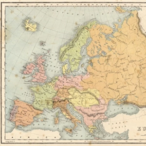
Photographic Print : MAPS / WORLD / 1827


![]()
Photo Prints from Mary Evans Picture Library
MAPS / WORLD / 1827
World map
Mary Evans Picture Library makes available wonderful images created for people to enjoy over the centuries
Media ID 592845
© Mary Evans Picture Library 2015 - https://copyrighthub.org/s0/hub1/creation/maryevans/MaryEvansPictureID/10042278
14"x11" Photo Print
Photo prints are produced on Kodak professional photo paper resulting in timeless and breath-taking prints which are also ideal for framing. The colors produced are rich and vivid, with accurate blacks and pristine whites, resulting in prints that are truly timeless and magnificent. Whether you're looking to display your prints in your home, office, or gallery, our range of photographic prints are sure to impress. Dimensions refers to the size of the paper in inches.
Our Photo Prints are in a large range of sizes and are printed on Archival Quality Paper for excellent colour reproduction and longevity. They are ideal for framing (our Framed Prints use these) at a reasonable cost. Alternatives include cheaper Poster Prints and higher quality Fine Art Paper, the choice of which is largely dependant on your budget.
Estimated Image Size (if not cropped) is 35.5cm x 23.8cm (14" x 9.4")
Estimated Product Size is 35.5cm x 27.9cm (14" x 11")
These are individually made so all sizes are approximate
Artwork printed orientated as per the preview above, with landscape (horizontal) orientation to match the source image.
FEATURES IN THESE COLLECTIONS
> Maps and Charts
> Early Maps
> Maps and Charts
> Related Images
> Maps and Charts
> World
EDITORS COMMENTS
This stunning print of a world map from 1827 is a captivating glimpse into the past, showcasing the intricate details and historical significance of cartography. The map, meticulously crafted with precision and artistry, offers a unique perspective on how our world was perceived nearly two centuries ago.
As we study this vintage map, we are transported back in time to an era when exploration and discovery were at the forefront of human endeavor. Each continent and ocean is carefully delineated, providing a window into the geographical knowledge of that period. From the vast expanse of uncharted territories to the familiar coastlines of well-known lands, every corner of the globe is represented with meticulous accuracy.
The intricate design elements and ornate embellishments on this map speak to the craftsmanship and dedication that went into creating such detailed works of art. It serves as a reminder of how maps have not only been essential tools for navigation but also valuable artifacts that reflect our evolving understanding of geography and culture.
Whether you are a history enthusiast, a cartography buff, or simply appreciate beautiful artwork, this print is sure to captivate your imagination and spark your curiosity about the world as it was seen in 1827. Displaying this piece in your home or office will undoubtedly add a touch of elegance and sophistication while inviting conversation about our shared global heritage.
MADE IN THE USA
Safe Shipping with 30 Day Money Back Guarantee
FREE PERSONALISATION*
We are proud to offer a range of customisation features including Personalised Captions, Color Filters and Picture Zoom Tools
SECURE PAYMENTS
We happily accept a wide range of payment options so you can pay for the things you need in the way that is most convenient for you
* Options may vary by product and licensing agreement. Zoomed Pictures can be adjusted in the Cart.