Home > Asia > Afghanistan > Maps
Jigsaw Puzzle : Map / Afghanistan C1860S


![]()
Jigsaw Puzzles from Mary Evans Picture Library
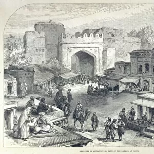
Map / Afghanistan C1860S
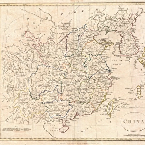
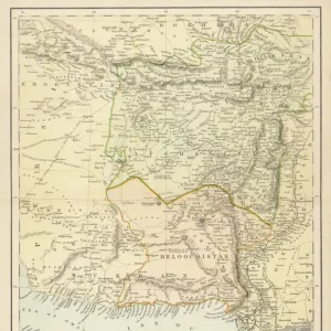
Map of Afghanistan and Beluchistan (note camel routes are measured in days, not miles)
Mary Evans Picture Library makes available wonderful images created for people to enjoy over the centuries
Media ID 608855
© Mary Evans Picture Library 2015 - https://copyrighthub.org/s0/hub1/creation/maryevans/MaryEvansPictureID/10114187
Afghanistan Camel Days Maps Measured Miles Note Routes Beluchistan
Jigsaw Puzzle (252 Pieces)
Discover the intrigue and history of Afghanistan and Beluchistan with our captivating jigsaw puzzle from the Media Storehouse collection, featuring an authentic map from Mary Evans Picture Library. Dated back to 1860, this antique map showcases the intricate details of the regions' geography, including camel routes measured in days, providing an engaging puzzle experience for history enthusiasts and puzzle lovers alike. Immerse yourself in the rich cultural heritage of this fascinating area while enjoying the satisfaction of piecing together this exquisite puzzle.
Made in the USA, 252-piece puzzles measure 11" x 14" (27.9 x 35.5 cm). Every puzzle is meticulously printed on glossy photo paper, which has a strong 1.33 mm thickness. Delivered in a black storage cardboard box, these puzzles are both stylish and practical. (Note: puzzles contain small parts and are not suitable for children under 3 years of age.)
Jigsaw Puzzles are an ideal gift for any occasion
Estimated Product Size is 28cm x 35.6cm (11" x 14")
These are individually made so all sizes are approximate
Artwork printed orientated as per the preview above, with portrait (vertical) orientation to match the source image.
FEATURES IN THESE COLLECTIONS
> Asia
> Afghanistan
> Maps
> Asia
> Afghanistan
> Related Images
> Asia
> Related Images
> Maps and Charts
> Early Maps
> Maps and Charts
> Related Images
EDITORS COMMENTS
This fascinating print from Mary Evans Picture Library showcases a historical map of Afghanistan and Beluchistan dating back to the 1860s. The intricate details on the map provide a glimpse into the past, highlighting important camel routes that were measured in days rather than miles. This unique feature offers insight into the mode of transportation and travel distances during that time period.
The map itself is a testament to the rich history of Asia, specifically focusing on Afghanistan and Beluchistan. It serves as a valuable educational tool for those interested in studying geography, history, or cultural heritage. The careful craftsmanship and attention to detail are evident in every aspect of this vintage map.
As we gaze upon this piece of art, we are transported back in time to an era where exploration and discovery were at the forefront. The significance of camel routes being measured in days reminds us of the challenges faced by travelers navigating through these regions centuries ago.
Overall, this print is not just a visual representation but also a historical document that sheds light on the complexities and nuances of Asian geography. It is truly a treasure trove for history buffs and enthusiasts alike.
MADE IN THE USA
Safe Shipping with 30 Day Money Back Guarantee
FREE PERSONALISATION*
We are proud to offer a range of customisation features including Personalised Captions, Color Filters and Picture Zoom Tools
SECURE PAYMENTS
We happily accept a wide range of payment options so you can pay for the things you need in the way that is most convenient for you
* Options may vary by product and licensing agreement. Zoomed Pictures can be adjusted in the Cart.