Home > Arts > Artists > C > Samuel de Champlain
MAP OF NEW FRANCE, 1612. The easterly portion of Samuel de Champlains 1612 map

![]()
Wall Art and Photo Gifts from Granger
MAP OF NEW FRANCE, 1612. The easterly portion of Samuel de Champlains 1612 map
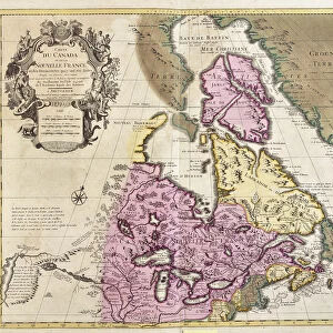
MAP OF NEW FRANCE, 1612.
The easterly portion of Samuel de Champlains 1612 map of New France
Granger holds millions of images spanning more than 25,000 years of world history, from before the Stone Age to the dawn of the Space Age
Media ID 12321040
1612 Canada Canadian Champlain Colony Detail Eastern New France Portolan Chart Samuel Settlement
FEATURES IN THESE COLLECTIONS
> Arts
> Artists
> C
> Samuel de Champlain
> Arts
> Landscape paintings
> Waterfall and river artworks
> River artworks
> Granger Art on Demand
> Maps
> Maps and Charts
> Early Maps
> North America
> Canada
> Maps
EDITORS COMMENTS
This print showcases the historical significance of the "MAP OF NEW FRANCE, 1612". Samuel de Champlain's meticulous cartographic skills come to life in this easterly portion of his map, which provides a fascinating glimpse into early French settlement and exploration in Canada. The intricate details on this map transport us back to the year 1612 when New France was still a burgeoning colony. As we study each line and symbol, we can almost feel the excitement and curiosity that must have fueled Champlain's expeditions along these uncharted rivers and coastlines. Champlain's dedication to accurately depicting the geography of New France is evident in every stroke of his pen. From the majestic river systems flowing through dense forests to carefully marked settlements dotting the landscape, this map serves as both an invaluable historical document and a work of art. As we admire this portolan chart, it becomes clear that it represents more than just geographical boundaries; it embodies centuries' worth of cultural exchange between indigenous peoples and European colonizers. It reminds us of the resilience and adaptability required for survival in such untamed lands. Granger Art on Demand has beautifully captured this piece from history, allowing us to appreciate its significance from our own homes. Whether you are a history enthusiast or simply intrigued by maps, this print offers an opportunity to delve into Canada's rich past while marveling at Champlain's mastery as a cartographer.
MADE IN THE USA
Safe Shipping with 30 Day Money Back Guarantee
FREE PERSONALISATION*
We are proud to offer a range of customisation features including Personalised Captions, Color Filters and Picture Zoom Tools
FREE COLORIZATION SERVICE
You can choose advanced AI Colorization for this picture at no extra charge!
SECURE PAYMENTS
We happily accept a wide range of payment options so you can pay for the things you need in the way that is most convenient for you
* Options may vary by product and licensing agreement. Zoomed Pictures can be adjusted in the Cart.