Home > Arts > Artists > C > John Chapman
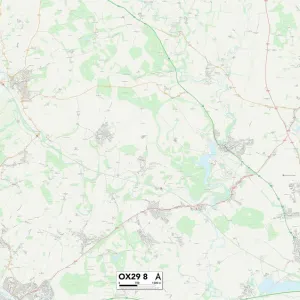
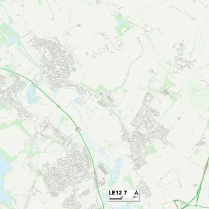
Leicester LE67 9 Map

![]()
Wall Art and Photo Gifts from Map Marketing
Leicester LE67 9 Map
Postcode Sector Map of Leicester LE67 9
Media ID 19973946
Ashby Road Beacon Close Beech Close Bell Close Birch Close Birchfield Avenue Bracken Way Bradgate Road Broad Lane Chapman Close Charnwood Drive Chestnut Walk Church Drive Cliffe Lane Cooper Close Cottage Lane Daisy Close Forest Road Grassy Lane Hill Lane Hillside Huntsmans Close Le67 Lea Lane Leicester Leicester Road London Road Main Street Marston Drive Mayflower Close Meadow Lane Mill Hill Lane Neville Drive Oakfield Avenue Park Avenue Pinewood Drive Poplar Avenue Preston Close Priory Lane Queen Street Rectory Road Robinson Way Shaw Lane St Michaels Close Stanton Lane Stoney Lane The Chase The Coppice The Green The Hawthorns The Laurels The Nook The Paddock The Pinfold The Rushes Thornton Lane Turnpike Way Upland Drive Valley Road Walnut Close Warner Close Warren Close Wesley Way Woodhouse Close Woodland Close Field Head
FEATURES IN THESE COLLECTIONS
> Arts
> Artists
> C
> John Chapman
> Arts
> Artists
> F
> John Field
> Arts
> Artists
> H
> John Hillers
> Arts
> Artists
> H
> John Hills
> Arts
> Artists
> J
> John Jackson
> Arts
> Artists
> T
> John Thomson
> Arts
> Artists
> W
> John Michael Wright
> Arts
> Landscape paintings
> Forest and woodland scenes
> Forest artwork
> Arts
> Portraits
> Pop art gallery
> Street art portraits
> Europe
> United Kingdom
> England
> London
> Related Images
> Map Marketing
> Postcode Sector Maps
> LE - Leicester
> Map Marketing
> UK Maps
MADE IN THE USA
Safe Shipping with 30 Day Money Back Guarantee
FREE PERSONALISATION*
We are proud to offer a range of customisation features including Personalised Captions, Color Filters and Picture Zoom Tools
SECURE PAYMENTS
We happily accept a wide range of payment options so you can pay for the things you need in the way that is most convenient for you
* Options may vary by product and licensing agreement. Zoomed Pictures can be adjusted in the Cart.