Home > Europe > United Kingdom > England > Durham > Neasham
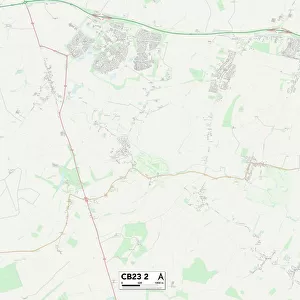
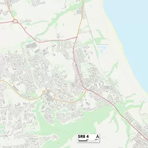
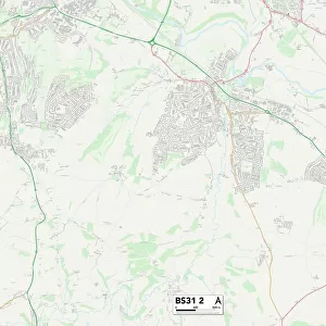
County Durham SR7 0 Map

![]()
Wall Art and Photo Gifts from Map Marketing
County Durham SR7 0 Map
Postcode Sector Map of County Durham SR7 0
Media ID 19981502
Ambleside Avenue Cheviot Court Clara Street County Durham Duke Street Durham Street Earl Street Glebe Drive Green Lane Hall Close Melrose Crescent Middleton Close Mill Road Milton Close Napier Road Nelson Street Norfolk Close Northwood Road Norton Avenue Oliver Street Salters Lane Seaton Seaton Crescent Stanley Street Station Crescent Station Road Stockton Road Stockton Street The Meadows Waterworks Road Woodlands
FEATURES IN THESE COLLECTIONS
> Animals
> Mammals
> Muridae
> House Mouse
> Arts
> Portraits
> Pop art gallery
> Street art portraits
> Europe
> United Kingdom
> England
> County Durham
> Durham
> Europe
> United Kingdom
> England
> County Durham
> Stanley
> Europe
> United Kingdom
> England
> Durham
> Durham
> Europe
> United Kingdom
> England
> Durham
> Neasham
> Europe
> United Kingdom
> England
> Durham
> Newlands
> Europe
> United Kingdom
> England
> Durham
> Seaton
> Europe
> United Kingdom
> England
> Durham
> Stanley
> Europe
> United Kingdom
> England
> Durham
> Woodland
> Map Marketing
> Postcode Sector Maps
> SR - Sunderland
> Map Marketing
> UK Maps
MADE IN THE USA
Safe Shipping with 30 Day Money Back Guarantee
FREE PERSONALISATION*
We are proud to offer a range of customisation features including Personalised Captions, Color Filters and Picture Zoom Tools
SECURE PAYMENTS
We happily accept a wide range of payment options so you can pay for the things you need in the way that is most convenient for you
* Options may vary by product and licensing agreement. Zoomed Pictures can be adjusted in the Cart.