Home > North America > United States of America > New York > New York > Bridges > Broadway Bridge
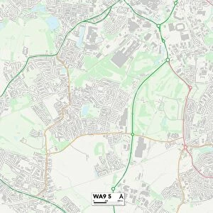
St. Helens WA10 5 Map

![]()
Wall Art and Photo Gifts from Map Marketing
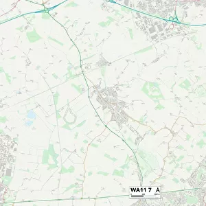
St. Helens WA10 5 Map
Postcode Sector Map of St. Helens WA10 5
Media ID 19979894
Acacia Grove Brentwood Close Broadway Brooklands Road Burrows Lane Chapel Lane Chelford Road Church Lane Clay Lane Davy Close Gawsworth Close Green Lane Griffin Close Hartford Road Hawthorn Drive Helens Holme Road Howards Lane Laurel Drive Ledbury Close Melrose Avenue Millfields Oaktree Road Osborne Road Poplar Avenue Richmond Close Sandfield Road Selkirk Drive Springfield Lane Summerfield Avenue Sycamore Close The Avenue The Cloisters The Close The Spires Watery Lane Eccleston Pike Place Whitefriars
FEATURES IN THESE COLLECTIONS
> Animals
> Mammals
> Muridae
> House Mouse
> Arts
> Landscape paintings
> Forest and woodland scenes
> Forest artwork
> Europe
> United Kingdom
> Scotland
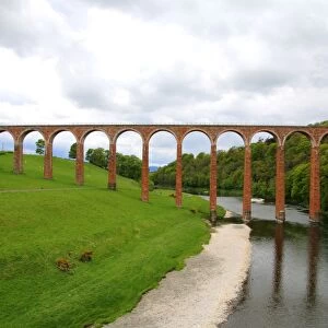
> Scottish Borders
> Melrose
> Europe
> United Kingdom
> Scotland
> Scottish Borders
> Selkirk
> Map Marketing
> Postcode Sector Maps
> WA - Warrington
> Maps and Charts
> Related Images
> North America
> United States of America
> New York
> New York
> Bridges
> Broadway Bridge
MADE IN THE USA
Safe Shipping with 30 Day Money Back Guarantee
FREE PERSONALISATION*
We are proud to offer a range of customisation features including Personalised Captions, Color Filters and Picture Zoom Tools
SECURE PAYMENTS
We happily accept a wide range of payment options so you can pay for the things you need in the way that is most convenient for you
* Options may vary by product and licensing agreement. Zoomed Pictures can be adjusted in the Cart.