Home > Europe > United Kingdom > England > London > Sights > Victoria Park
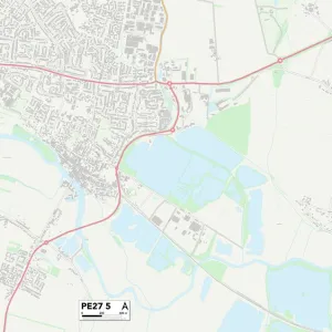
West Norfolk PE36 6 Map

![]()
Wall Art and Photo Gifts from Map Marketing
West Norfolk PE36 6 Map
Postcode Sector Map of West Norfolk PE36 6
Media ID 19976936
Austin Street Beach Road Belgrave Avenue Broadwater Road Chapel Bank Church Road Church Street Clarence Road Cliff Terrace Cromer Road Glebe Avenue Golf Course Road Green Lane Hall Lane Hamilton Road Hastings Drive High Street Howards Close James Street Kelsey Close Kings Road Lincoln Street Main Road Northgate Priory Court Queens Drive Queens Gardens Ringstead Road Sandy Lane Sea Lane Ship Lane Smugglers Lane St Georges Court Station Lane The Green Victoria Avenue Waterworks Road West Norfolk Westgate Street York Avenue Thornham
FEATURES IN THESE COLLECTIONS
> Arts
> Artists
> H
> George Howard
> Arts
> Artists
> S
> George Shepherd
> Arts
> Portraits
> Pop art gallery
> Street art portraits
> Europe
> United Kingdom
> England
> London
> Sights
> St James Park
> Europe
> United Kingdom
> England
> London
> Sights
> Victoria Park
> Europe
> United Kingdom
> England
> Norfolk
> Cromer
> Europe
> United Kingdom
> England
> Norfolk
> Eastgate
> Europe
> United Kingdom
> England
> Norfolk
> High Green
> Europe
> United Kingdom
> England
> Norfolk
> Holme next the Sea
> Europe
> United Kingdom
> England
> Norfolk
> Hunstanton
> Map Marketing
> Postcode Sector Maps
> PE - Peterborough
MADE IN THE USA
Safe Shipping with 30 Day Money Back Guarantee
FREE PERSONALISATION*
We are proud to offer a range of customisation features including Personalised Captions, Color Filters and Picture Zoom Tools
SECURE PAYMENTS
We happily accept a wide range of payment options so you can pay for the things you need in the way that is most convenient for you
* Options may vary by product and licensing agreement. Zoomed Pictures can be adjusted in the Cart.