Home > Europe > United Kingdom > England > London > Sights > Mile End Park
Lincoln LN11 7 Map

![]()
Wall Art and Photo Gifts from Map Marketing
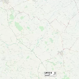
Lincoln LN11 7 Map
Postcode Sector Map of Lincoln LN11 7
Media ID 19975334
Abbey Park Acorn Avenue Back Lane Browns Lane Cemetery Road Chapel Lane Chestnut Drive Church End Church Lane Church Walk Churchill Close Churchill Road Commercial Road Common Lane Cowslip Lane Crabtree Lane East Row Eastfield Road Fen Lane Flash Lane Grange Lane Green Lane High Street Holmes Close Holmes Lane Ings Lane Ivy Lane Jubilee Road King Street Kings Court Lincoln Lock Road Locksley Close Louth Road Main Road Marsh Lane Meadow Lane Mill Bank Mill Garth Mill Lane Millfield Road Mottram Close North End Lane Orchard Court Park Row Pump Lane River Lane School Lane Sea Lane Sea View South Road St Annes Avenue St Leonards Lane Thames Street The Bank The Hill Town Street Walnut Close Warren Road Wembley Road West Lane Donna Nook
FEATURES IN THESE COLLECTIONS
> Animals
> Birds
> Passerines
> Wattled Crows
> Saddleback
> Animals
> Fishes
> S
> Swallower
> Animals
> Reptiles
> Snakes
> King Brown
> Arts
> Artists
> B
> Peter Brown
> Arts
> Artists
> C
> King Charles
> Arts
> Artists
> G
> Charles Green
> Arts
> Landscape paintings
> Waterfall and river artworks
> River artworks
> Arts
> Portraits
> Pop art gallery
> Street art portraits
> Europe
> United Kingdom
> England
> London
> River Thames
> Europe
> United Kingdom
> England
> London
> Sights
> Mile End Park
> Map Marketing
> Postcode Sector Maps
> LN - Lincoln
MADE IN THE USA
Safe Shipping with 30 Day Money Back Guarantee
FREE PERSONALISATION*
We are proud to offer a range of customisation features including Personalised Captions, Color Filters and Picture Zoom Tools
SECURE PAYMENTS
We happily accept a wide range of payment options so you can pay for the things you need in the way that is most convenient for you
* Options may vary by product and licensing agreement. Zoomed Pictures can be adjusted in the Cart.