Home > Europe > United Kingdom > England > London > Boroughs > Lewisham
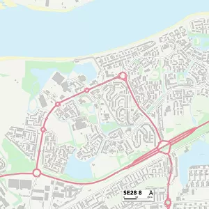
Lewisham SE14 5 Map

![]()
Wall Art and Photo Gifts from Map Marketing
Lewisham SE14 5 Map
Postcode Sector Map of Lewisham SE14 5
Media ID 19977772
Billington Road Fern Court Harts Lane Hatfield Close Lewisham Myers Lane Nettleton Road New Cross Road Pankhurst Close Pump Lane Robinson Way Romney Close Samuel Close St Catherines Drive Swallow Close Troutbeck Road Ventnor Road Water Lane Wellington Close
FEATURES IN THESE COLLECTIONS
> Animals
> Fishes
> S
> Swallower
> Arts
> Artists
> L
> Samuel Lane
> Arts
> Artists
> R
> Robert Robinson
> Arts
> Portraits
> Pop art gallery
> Street art portraits
> Europe
> United Kingdom
> England
> London
> Boroughs
> Lewisham
> Europe
> United Kingdom
> England
> Surrey
> Related Images
> Map Marketing
> Postcode Sector Maps
> SE - London SE
> Maps and Charts
> Related Images
> North America
> United States of America
> New York
> New York
> Sights
> Wall Street
MADE IN THE USA
Safe Shipping with 30 Day Money Back Guarantee
FREE PERSONALISATION*
We are proud to offer a range of customisation features including Personalised Captions, Color Filters and Picture Zoom Tools
SECURE PAYMENTS
We happily accept a wide range of payment options so you can pay for the things you need in the way that is most convenient for you
* Options may vary by product and licensing agreement. Zoomed Pictures can be adjusted in the Cart.