Home > Arts > Artists > B > William Brown
South Norfolk IP22 5 Map

![]()
Wall Art and Photo Gifts from Map Marketing
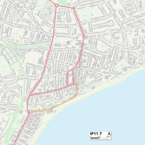
South Norfolk IP22 5 Map
Postcode Sector Map of South Norfolk IP22 5
Media ID 19971852
Audley Close Back Lane Blenheim Way Bridge Road Chequers Lane Church Close Common Road Factory Lane Fen Lane Green Lane Grove Road Hall Lane Hall Road Heywood Road High Road Lewis Drive Long Lane Lower Street Malthouse Lane Manor Drive Manor Road Mansell Close Market Lane Mill Green Mill Road Millway Lane New Road Old Rectory Close Pavilion Court Potash Lane Queensway Rectory Road Slough Lane Station Road The Close Tudor Avenue Upper Street Wash Lane Fenlands Roydon Roydon Fen South Norfolk
FEATURES IN THESE COLLECTIONS
> Arts
> Artists
> B
> William Brown
> Arts
> Portraits
> Pop art gallery
> Street art portraits
> Europe
> United Kingdom
> England
> Norfolk
> Burston
> Europe
> United Kingdom
> England
> Norfolk
> Diss
> Europe
> United Kingdom
> England
> Norfolk
> Fen Street
> Europe
> United Kingdom
> England
> Norfolk
> High Green
> Europe
> United Kingdom
> England
> Norfolk
> Horning
> Europe
> United Kingdom
> England
> Norfolk
> Lower Green
> Europe
> United Kingdom
> England
> Norfolk
> Related Images
> Europe
> United Kingdom
> England
> Norfolk
> Roydon
> Map Marketing
> Postcode Sector Maps
> IP - Ipswich
MADE IN THE USA
Safe Shipping with 30 Day Money Back Guarantee
FREE PERSONALISATION*
We are proud to offer a range of customisation features including Personalised Captions, Color Filters and Picture Zoom Tools
SECURE PAYMENTS
We happily accept a wide range of payment options so you can pay for the things you need in the way that is most convenient for you
* Options may vary by product and licensing agreement. Zoomed Pictures can be adjusted in the Cart.