Home > Europe > United Kingdom > Wales > Denbighshire > Ruthin
Bridgend CF35 5 Map

![]()
Wall Art and Photo Gifts from Map Marketing
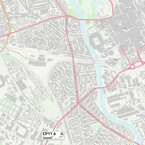
Bridgend CF35 5 Map
Postcode Sector Map of Bridgend CF35 5
Media ID 19967156
Abbey Gardens Abbey Road Bridgend Brookside Bryn Road Cae Glas East Street Felindre Glan Y Nant Glenwood Close Grange Crescent Hawthorn Drive Kingswood Close Little Acre Macdonald Avenue Manor Court Manor Drive Meadow Close New Road Park View Parklands St Brides Road St Johns Drive St Marys Close Stony Lane The Court The Green The Meadows Wick Road Willow Close Ruthin Waterton
FEATURES IN THESE COLLECTIONS
> Arts
> Artists
> H
> John Hillers
> Arts
> Artists
> H
> John Hills
> Arts
> Portraits
> Pop art gallery
> Street art portraits
> Europe
> United Kingdom
> Scotland
> Highlands
> Wick
> Europe
> United Kingdom
> Scotland
> West Lothian
> Bridgend
> Europe
> United Kingdom
> Wales
> Denbighshire
> Ruthin
> Europe
> United Kingdom
> Wales
> Mid Glamorgan
> Bridgend
> Map Marketing
> Postcode Sector Maps
> CF - Cardiff
> Maps and Charts
> Related Images
MADE IN THE USA
Safe Shipping with 30 Day Money Back Guarantee
FREE PERSONALISATION*
We are proud to offer a range of customisation features including Personalised Captions, Color Filters and Picture Zoom Tools
SECURE PAYMENTS
We happily accept a wide range of payment options so you can pay for the things you need in the way that is most convenient for you
* Options may vary by product and licensing agreement. Zoomed Pictures can be adjusted in the Cart.