Home > Europe > United Kingdom > England > Birmingham > Area > Churchfield
Sandwell B71 4 Map

![]()
Wall Art and Photo Gifts from Map Marketing
Sandwell B71 4 Map
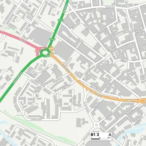
Postcode Sector Map of Sandwell B71 4
Media ID 19965269
Albion Road All Saints Way Belvedere Close Birmingham Road Churchfield Colliery Road Devonshire Drive Grafton Road Graham Road Hallam Close Hallam Street Little Lane Lloyd Street Park Crescent Parsonage Street Reform Street Salters Lane Sandwell Sheridan Street St Stephens Road Stoney Lane Summer Street Taylors Lane Vale Street Lyndon
FEATURES IN THESE COLLECTIONS
> Arts
> Portraits
> Pop art gallery
> Street art portraits
> Europe
> United Kingdom
> England
> Birmingham
> Area
> Churchfield
> Europe
> United Kingdom
> England
> Birmingham
> Area
> Lyndon Green
> Europe
> United Kingdom
> England
> London
> Boroughs
> Lewisham
> Map Marketing
> Postcode Sector Maps
> B - Birmingham
> Maps and Charts
> Related Images
MADE IN THE USA
Safe Shipping with 30 Day Money Back Guarantee
FREE PERSONALISATION*
We are proud to offer a range of customisation features including Personalised Captions, Color Filters and Picture Zoom Tools
SECURE PAYMENTS
We happily accept a wide range of payment options so you can pay for the things you need in the way that is most convenient for you
* Options may vary by product and licensing agreement. Zoomed Pictures can be adjusted in the Cart.