Home > Europe > United Kingdom > England > Birmingham > Area > Witton
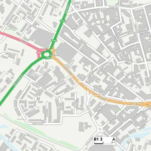
Birmingham B6 7 Map

![]()
Wall Art and Photo Gifts from Map Marketing
Birmingham B6 7 Map
Postcode Sector Map of Birmingham B6 7
Media ID 19965804
Alfred Street Aston Birch Road Birmingham Bourne Road Chancel Way Cheshire Road Church Lane Church Road Dulverton Road Electric Avenue First Avenue Gladstone Street Grosvenor Road Jameson Road Lichfield Road Montague Street Moor Lane Pavilion Drive Poplar Drive Priory Road Queens Road Queensway Sutherland Street The Hollies Third Avenue Union Road Westwood Road Witton
FEATURES IN THESE COLLECTIONS
> Arts
> Artists
> D
> Alfred
> Related Images
> Arts
> Artists
> E
> Alfred East
> Arts
> Portraits
> Pop art gallery
> Street art portraits
> Europe
> United Kingdom
> England
> Birmingham
> Area
> Aston
> Europe
> United Kingdom
> England
> Birmingham
> Area
> Witton
> Europe
> United Kingdom
> England
> Cheshire
> Aston
> Europe
> United Kingdom
> England
> Cheshire
> Croft
> Europe
> United Kingdom
> England
> Cheshire
> Related Images
> Europe
> United Kingdom
> Scotland
> Sutherland
> Map Marketing
> Postcode Sector Maps
> B - Birmingham
> Maps and Charts
> Related Images
MADE IN THE USA
Safe Shipping with 30 Day Money Back Guarantee
FREE PERSONALISATION*
We are proud to offer a range of customisation features including Personalised Captions, Color Filters and Picture Zoom Tools
SECURE PAYMENTS
We happily accept a wide range of payment options so you can pay for the things you need in the way that is most convenient for you
* Options may vary by product and licensing agreement. Zoomed Pictures can be adjusted in the Cart.