Home > Europe > France > Maps
Jigsaw Puzzle : Map / Europe / Germany 1880S


![]()
Jigsaw Puzzles from Mary Evans Picture Library
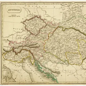
Map / Europe / Germany 1880S
Map of the German Empire (southern part) after the war with France, including Alsace and Lorraine
Mary Evans Picture Library makes available wonderful images created for people to enjoy over the centuries
Media ID 4357663
© Mary Evans Picture Library 2015 - https://copyrighthub.org/s0/hub1/creation/maryevans/MaryEvansPictureID/10114038
Alsace Including Lorraine Maps Southern
Jigsaw Puzzle (252 Pieces)
Discover the rich history of Europe with our captivating jigsaw puzzles from Media Storehouse. Our "Map / Europe / Germany 1880s" puzzle, featuring an intricately detailed map of the German Empire during the late 19th century, is a must-have for history enthusiasts and puzzle lovers alike. This beautiful puzzle, sourced from Mary Evans Prints Online, showcases the southern part of Germany after the war with France, including Alsace and Lorraine. Engage your mind and challenge yourself as you piece together this historical puzzle and bring the past to life in your own home.
Made in the USA, 252-piece puzzles measure 11" x 14" (27.9 x 35.5 cm). Every puzzle is meticulously printed on glossy photo paper, which has a strong 1.33 mm thickness. Delivered in a black storage cardboard box, these puzzles are both stylish and practical. (Note: puzzles contain small parts and are not suitable for children under 3 years of age.)
Jigsaw Puzzles are an ideal gift for any occasion
Estimated Product Size is 35.6cm x 28cm (14" x 11")
These are individually made so all sizes are approximate
Artwork printed orientated as per the preview above, with landscape (horizontal) orientation to match the source image.
FEATURES IN THESE COLLECTIONS
> Maps and Charts
> Early Maps
EDITORS COMMENTS
This vintage map print showcases the southern part of the German Empire in the 1880s, following the war with France. The detailed cartography includes regions such as Alsace and Lorraine, which were hotly contested territories during this period of history. The map provides a fascinating glimpse into Europe's political landscape at a time when borders were constantly shifting.
The intricate design and historical significance of this map make it a captivating piece for any history enthusiast or collector. It serves as a reminder of the complex relationships between nations and the ever-changing nature of geopolitics.
With its muted color palette and intricate details, this map exudes an old-world charm that is sure to add character to any space. Whether displayed in a study, library, or living room, this print is bound to spark conversations about European history and the legacy of past conflicts.
Overall, this map print from Mary Evans Prints Online is not just a decorative piece but also a valuable historical artifact that offers insight into Germany's territorial expansion and geopolitical ambitions in the late 19th century. A must-have for anyone interested in European history or cartography.
MADE IN THE USA
Safe Shipping with 30 Day Money Back Guarantee
FREE PERSONALISATION*
We are proud to offer a range of customisation features including Personalised Captions, Color Filters and Picture Zoom Tools
SECURE PAYMENTS
We happily accept a wide range of payment options so you can pay for the things you need in the way that is most convenient for you
* Options may vary by product and licensing agreement. Zoomed Pictures can be adjusted in the Cart.