Home > Europe > France > Paris > Maps
Framed Print : Map / Europe / France / Paris


![]()
Framed Photos from Mary Evans Picture Library
Map / Europe / France / Paris
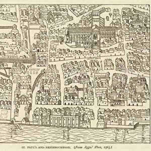
Map showing the growth of Paris from its earliest origins to the latest projects under Napoleon III
Mary Evans Picture Library makes available wonderful images created for people to enjoy over the centuries
Media ID 594576
© Mary Evans Picture Library 2015 - https://copyrighthub.org/s0/hub1/creation/maryevans/MaryEvansPictureID/10046917
1860 Earliest Growth I Ii Latest Maps Napoleon Origins Projects
22"x18" Modern Frame
Introducing the stunning Framed Print from Media Storehouse and Mary Evans Picture Library, featuring a captivating map of Paris, France. This exquisite piece showcases the growth of Paris from its earliest origins to the latest projects under Napoleon III. Each detail on this map is meticulously rendered, offering a fascinating glimpse into the rich history of the City of Light. Bring the allure of Paris into your home or office with this beautiful, high-quality framed print. Perfect for history enthusiasts, travelers, or anyone who appreciates the beauty and complexity of urban development. Order yours today and let this map transport you on a journey through time.
20x16 Print in an MDF Wooden Frame with 180 gsm Satin Finish Paper. Glazed using shatter proof thin plexiglass. Frame thickness is 1 inch and depth 0.75 inch. Fluted cardboard backing held with clips. Supplied ready to hang with sawtooth hanger and rubber bumpers. Spot clean with a damp cloth. Packaged foam wrapped in a card.
Contemporary Framed and Mounted Prints - Professionally Made and Ready to Hang
Estimated Image Size (if not cropped) is 50.8cm x 45.7cm (20" x 18")
Estimated Product Size is 55.9cm x 45.7cm (22" x 18")
These are individually made so all sizes are approximate
Artwork printed orientated as per the preview above, with landscape (horizontal) orientation to match the source image.
FEATURES IN THESE COLLECTIONS
> Europe
> France
> Paris
> Maps
> Europe
> France
> Paris
> Related Images
> Europe
> Related Images
> Maps and Charts
> Early Maps
> Maps and Charts
> Related Images
> Mary Evans Prints Online
> Maps
EDITORS COMMENTS
This print from Mary Evans Picture Library showcases a detailed map of Europe, specifically focusing on the growth of Paris throughout history. From its earliest origins to the latest projects under Napoleon III in 1860, this map provides a fascinating glimpse into the historical development of one of the most iconic cities in France.
The intricate details and markings on the map offer insight into how Paris evolved over time, highlighting key landmarks and significant changes that took place under Napoleon I and II. The viewer can trace the city's expansion and transformation through various eras, gaining a deeper understanding of its rich history and cultural significance.
As we study this map, we are transported back in time to witness the evolution of Paris unfold before our eyes. It serves as a reminder of the city's resilience and adaptability, showcasing how it has continuously reinvented itself to become the vibrant metropolis we know today.
Whether you're a history buff or simply appreciate beautiful cartography, this print is sure to captivate your imagination and spark your curiosity about Paris' past. Dive into this visual journey through time with Mary Evans Prints Online and explore the fascinating story behind one of Europe's most beloved cities.
MADE IN THE USA
Safe Shipping with 30 Day Money Back Guarantee
FREE PERSONALISATION*
We are proud to offer a range of customisation features including Personalised Captions, Color Filters and Picture Zoom Tools
SECURE PAYMENTS
We happily accept a wide range of payment options so you can pay for the things you need in the way that is most convenient for you
* Options may vary by product and licensing agreement. Zoomed Pictures can be adjusted in the Cart.