Home > Europe > Belarus > Maps
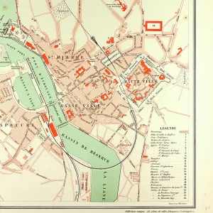
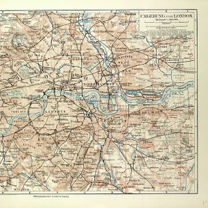
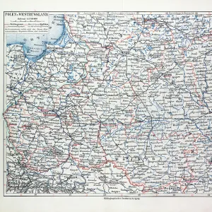
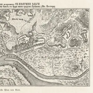
Photographic Print : Map of Poland, Belarus and Ukraine, 1899


![]()
Photo Prints from Liszt Collection
Map of Poland, Belarus and Ukraine, 1899
Liszt Collection of nineteenth-century engravings and images to browse and enjoy
Media ID 12974349
© Quint Lox Limited
1899 Plan Poland Ukraine Warsaw Belarus Minsk
14"x11" Photo Print
Step back in time with our exquisite antique map print from the Liszt Collection. This beautifully detailed representation of Poland, Belarus, and Ukraine, as they appeared in 1899, is a captivating addition to any home or office. The intricate border design and vibrant colors bring history to life, making it an ideal conversation starter. Our high-quality photographic print preserves the authenticity and character of this rare map, ensuring a stunning and timeless piece for your collection.
Photo prints are produced on Kodak professional photo paper resulting in timeless and breath-taking prints which are also ideal for framing. The colors produced are rich and vivid, with accurate blacks and pristine whites, resulting in prints that are truly timeless and magnificent. Whether you're looking to display your prints in your home, office, or gallery, our range of photographic prints are sure to impress. Dimensions refers to the size of the paper in inches.
Our Photo Prints are in a large range of sizes and are printed on Archival Quality Paper for excellent colour reproduction and longevity. They are ideal for framing (our Framed Prints use these) at a reasonable cost. Alternatives include cheaper Poster Prints and higher quality Fine Art Paper, the choice of which is largely dependant on your budget.
Estimated Product Size is 35.5cm x 27.9cm (14" x 11")
These are individually made so all sizes are approximate
Artwork printed orientated as per the preview above, with landscape (horizontal) or portrait (vertical) orientation to match the source image.
FEATURES IN THESE COLLECTIONS
> Europe
> Belarus
> Related Images
> Europe
> Poland
> Related Images
> Europe
> Ukraine
> Related Images
> Liszt Collection
> Engravings
EDITORS COMMENTS
This print showcases a meticulously detailed "Map of Poland, Belarus and Ukraine" from the year 1899. A true testament to the artistry of the nineteenth century, this engraved image transports us back in time to an era where maps were not only functional but also works of art. The map encompasses key cities such as Minsk and Warsaw, providing a historical glimpse into these regions during that period. The illustrative technique employed in this piece is truly remarkable, with intricate engravings capturing every minute detail of the landscape. This vintage map exudes a sense of nostalgia and charm, evoking memories of a bygone era when cartography was still in its infancy. With its retro-styled aesthetic and Victorian influences, this print from Arkheia's collection seamlessly blends history with artistic expression. It serves as a visual reminder of how far we have come in terms of technological advancements while simultaneously appreciating the craftsmanship that went into creating such masterpieces. Whether you are an avid collector or simply fascinated by history and culture, this print offers an opportunity to delve into the past through both educational and aesthetic lenses. Let yourself be transported back to 1899 as you explore the intricacies of Poland, Belarus, and Ukraine through this stunning piece from Liszt Collection's archives.
MADE IN THE USA
Safe Shipping with 30 Day Money Back Guarantee
FREE PERSONALISATION*
We are proud to offer a range of customisation features including Personalised Captions, Color Filters and Picture Zoom Tools
SECURE PAYMENTS
We happily accept a wide range of payment options so you can pay for the things you need in the way that is most convenient for you
* Options may vary by product and licensing agreement. Zoomed Pictures can be adjusted in the Cart.