Home > Asia > India > Maps
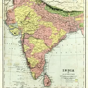
1862, Johnson Map of India and Southeast Asia, topography, cartography, geography

![]()
Wall Art and Photo Gifts from Liszt Collection
1862, Johnson Map of India and Southeast Asia, topography, cartography, geography
1862, Johnson Map of India and Southeast Asia
Liszt Collection of nineteenth-century engravings and images to browse and enjoy
Media ID 14007733
© Artokoloro Quint Lox Limited
1862 Antique Map Atlas Chart Geographic Latitude Longitude Mappa Mundi Old Antique Plan Old Antique View Old Map Ols Antique Map Rare Old Maps Topo
FEATURES IN THESE COLLECTIONS
> Maps and Charts
> Early Maps
> Maps and Charts
> India
> Maps and Charts
> World
EDITORS COMMENTS
This print showcases the 1862 Johnson Map of India and Southeast Asia, a true masterpiece in topography, cartography, and geography. The intricate details of this vintage map take us on a journey through time, revealing the ancient world as it was perceived over a century ago. The carefully illustrated land formations and geographic features provide an invaluable resource for understanding the region's rich history. With its precise depiction of latitude and longitude lines, this map serves as both a navigational tool and an artistic representation of our planet's diverse landscapes. As we explore this rare old map, we are transported to an era when exploration and discovery were at their peak. Its aged appearance adds a touch of historical charm while reminding us of the countless journeys undertaken by adventurers who relied on such maps to navigate uncharted territories. This decorative piece not only captures the essence of cartographic art but also invites us to appreciate the beauty inherent in geographical representations. It is a testament to human curiosity about our world's vastness—a mappa mundi that encapsulates centuries-old knowledge within its delicate gridlines. Whether you are an avid traveler or simply fascinated by history, this antique map offers a glimpse into another time—an invitation to immerse yourself in the wonders that lie beyond familiar horizons.
MADE IN THE USA
Safe Shipping with 30 Day Money Back Guarantee
FREE PERSONALISATION*
We are proud to offer a range of customisation features including Personalised Captions, Color Filters and Picture Zoom Tools
SECURE PAYMENTS
We happily accept a wide range of payment options so you can pay for the things you need in the way that is most convenient for you
* Options may vary by product and licensing agreement. Zoomed Pictures can be adjusted in the Cart.