Home > South America > Bolivia > Maps
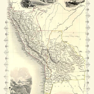
1850, Mitchell Map of Peru and Bolivia, topography, cartography, geography, land

![]()
Wall Art and Photo Gifts from Liszt Collection
1850, Mitchell Map of Peru and Bolivia, topography, cartography, geography, land
1850, Mitchell Map of Peru and Bolivia
Liszt Collection of nineteenth-century engravings and images to browse and enjoy
Media ID 14007317
© Artokoloro Quint Lox Limited
1850 Antique Map Atlas Chart Geographic Latitude Longitude Mappa Mundi Old Antique Plan Old Antique View Old Map Ols Antique Map Rare Old Maps Topo
FEATURES IN THESE COLLECTIONS
> Maps and Charts
> Early Maps
> Maps and Charts
> World
> South America
> Bolivia
> Maps
> South America
> Peru
> Maps
EDITORS COMMENTS
This print showcases the remarkable 1850 Mitchell Map of Peru and Bolivia, a true masterpiece in the realms of topography, cartography, and geography. With its intricate details and precise land representations, this vintage map takes us on a journey back in time to explore these South American nations as they were over a century ago. The illustration beautifully captures the diverse landscapes, from towering mountains to sprawling plains, allowing us to appreciate the rich topographic features that define Peru and Bolivia. The carefully plotted grid lines of latitude and longitude add an element of precision to this artistic creation while highlighting the importance of accurate navigation during that era. As we gaze upon this ancient relic, we are transported into a world where exploration was at its peak. This historic map serves as a reminder of how far our understanding of Earth's geography has come since then. Its decorative elements evoke nostalgia for an age when maps were not only functional tools but also works of art. Preserved with care through time, this rare old map offers glimpses into forgotten regions and ignites our curiosity about past civilizations that once thrived within these borders. It is truly an invaluable piece for history enthusiasts or anyone seeking to delve deeper into the geographical wonders that shaped our world.
MADE IN THE USA
Safe Shipping with 30 Day Money Back Guarantee
FREE PERSONALISATION*
We are proud to offer a range of customisation features including Personalised Captions, Color Filters and Picture Zoom Tools
SECURE PAYMENTS
We happily accept a wide range of payment options so you can pay for the things you need in the way that is most convenient for you
* Options may vary by product and licensing agreement. Zoomed Pictures can be adjusted in the Cart.