Home > Europe > Luxembourg > Maps
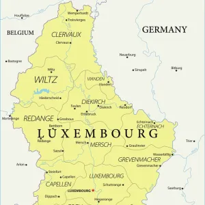
1730, Homann Heirs Map of Belgium and Luxembourg, topography, cartography, geography

![]()
Wall Art and Photo Gifts from Liszt Collection
1730, Homann Heirs Map of Belgium and Luxembourg, topography, cartography, geography
1730, Homann Heirs Map of Belgium and Luxembourg
Liszt Collection of nineteenth-century engravings and images to browse and enjoy
Media ID 14006593
© Artokoloro Quint Lox Limited
1730 Antique Map Atlas Chart Geographic Latitude Longitude Mappa Mundi Old Antique Plan Old Antique View Old Map Ols Antique Map Rare Old Maps Topo
FEATURES IN THESE COLLECTIONS
> Europe
> Luxembourg
> Maps
> Maps and Charts
> Early Maps
> Maps and Charts
> Luxembourg
> Maps and Charts
> World
EDITORS COMMENTS
This print showcases the exquisite "1730, Homann Heirs Map of Belgium and Luxembourg". A true masterpiece of topography, cartography, and geography, this vintage map takes us on a journey through time. With its intricate details and precise measurements, it offers a glimpse into the ancient world. The paper's aged texture adds to the charm of this historical artifact while evoking a sense of nostalgia. Its decorative elements make it an art piece in itself, reflecting the skillful craftsmanship of its creators. This rare old map is not only a visual delight but also serves as a valuable tool for navigation and exploration. As we gaze upon this remarkable illustration, we are transported back to an era when maps were meticulously hand-drawn with utmost precision. The grid lines representing latitude and longitude create a geometric harmony that guides our eyes across the vast regions depicted. With every contour line carefully etched onto the surface, we can almost feel the land beneath our fingertips. It reminds us that geography is not merely about physical spaces but also about understanding cultures and histories that have shaped these lands over centuries. This Homann Heirs Map invites us to embark on a historical journey filled with discovery and wonderment. It serves as a testament to human curiosity about our world's past while reminding us of how far we have come in terms of technological advancements in cartography.
MADE IN THE USA
Safe Shipping with 30 Day Money Back Guarantee
FREE PERSONALISATION*
We are proud to offer a range of customisation features including Personalised Captions, Color Filters and Picture Zoom Tools
SECURE PAYMENTS
We happily accept a wide range of payment options so you can pay for the things you need in the way that is most convenient for you
* Options may vary by product and licensing agreement. Zoomed Pictures can be adjusted in the Cart.