Jigsaw Puzzle > Universal Images Group (UIG) > Art > Painting, Sculpture & Prints > Cartography
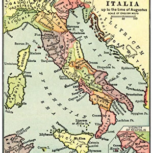
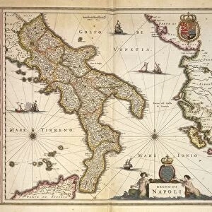
Jigsaw Puzzle : Map of Italy, from Theatrum Orbis Terrarum by Willem Blaeu, Amsterdam, 1635-1645


![]()
Jigsaw Puzzles From Universal Images Group (UIG)
Map of Italy, from Theatrum Orbis Terrarum by Willem Blaeu, Amsterdam, 1635-1645
Cartography, Germany, 17th century. Map of Italy, from Theatrum Orbis Terrarum by Willem Blaeu, Amsterdam, 1635-1645
Universal Images Group (UIG) manages distribution for many leading specialist agencies worldwide
Media ID 9504323
© DEA / A. DAGLI ORTI
17th Century Coastline Theatrum Orbis Terrarum Willem Bleau Great Britian
Jigsaw Puzzle (520 Pieces)
Discover the rich history and culture of Italy with our exquisite jigsaw puzzle from Media Storehouse. This captivating puzzle features a detailed map of Italy, taken from Theatrum Orbis Terrarum, an iconic atlas published by Willem Blaeu in Amsterdam between 1635 and 1645. This intricately designed puzzle showcases the cartography of the 17th century, offering a unique and educational experience. Perfect for puzzle enthusiasts, history buffs, or anyone seeking a challenge, immerse yourself in the beauty and intricacy of this timeless masterpiece.
Made in the USA, 520-piece puzzles measure 16" x 20" (40.6 x 50.8 cm). Every puzzle is meticulously printed on glossy photo paper, which has a strong 1.33 mm thickness. Delivered in a black storage cardboard box, these puzzles are both stylish and practical. (Note: puzzles contain small parts and are not suitable for children under 3 years of age.)
Jigsaw Puzzles are an ideal gift for any occasion
Estimated Product Size is 50.8cm x 40.5cm (20" x 15.9")
These are individually made so all sizes are approximate
Artwork printed orientated as per the preview above, with landscape (horizontal) or portrait (vertical) orientation to match the source image.
EDITORS COMMENTS
This print showcases a remarkable piece of cartographic history - the Map of Italy from Theatrum Orbis Terrarum by Willem Blaeu, printed in Amsterdam between 1635 and 1645. A true testament to the artistry and precision of 17th-century German cartography, this antique map offers a fascinating glimpse into Italy's geographical landscape during that era. The intricate details on this horizontal map are truly awe-inspiring. From the majestic coastline that stretches along the Mediterranean Sea to the meticulously drawn borders and cities, every element is crafted with utmost care and accuracy. It serves as a visual time capsule, transporting us back to an era when exploration and discovery were at their peak. As we delve deeper into this historical gem, it becomes evident that it holds immense value beyond its aesthetic appeal. This map played a crucial role in shaping our understanding of Italy's geography centuries ago. Its significance lies not only in providing navigational guidance but also in documenting political boundaries and territorial claims. Willem Blaeu's expertise shines through his masterful illustration and painting techniques employed in creating this masterpiece. Without any human presence captured within its frame, this image invites us to appreciate the sheer beauty of nature itself - untouched by modern influences. In conclusion, this print immortalizes an invaluable artifact from the past - one that seamlessly combines artistry with scientific precision. It stands as a testament to both human curiosity about our world and our ability to capture its essence through maps like these.
MADE IN THE USA
Safe Shipping with 30 Day Money Back Guarantee
FREE PERSONALISATION*
We are proud to offer a range of customisation features including Personalised Captions, Color Filters and Picture Zoom Tools
SECURE PAYMENTS
We happily accept a wide range of payment options so you can pay for the things you need in the way that is most convenient for you
* Options may vary by product and licensing agreement. Zoomed Pictures can be adjusted in the Basket.