Jigsaw Puzzle > Africa > Morocco > Maps
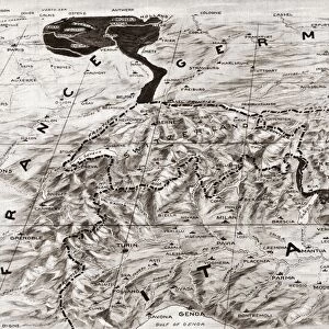
Jigsaw Puzzle : Spain. War of Africa (1859-1860). Maps of Morocco
. Maps of Morocco")
. Maps of Morocco")


![]()
Jigsaw Puzzles from Mary Evans Picture Library
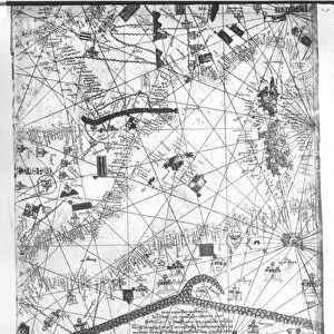
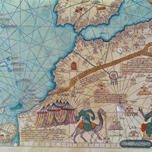
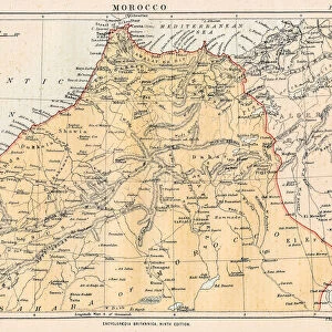
Spain. War of Africa (1859-1860). Maps of Morocco
Mary Evans Picture Library makes available wonderful images created for people to enjoy over the centuries
Media ID 8277719
© Mary Evans Picture Library 2015 - https://copyrighthub.org/s0/hub1/creation/maryevans/MaryEvansPictureID/10684115
Cartographic Cartographies Cartography Donostia Garbage Maps Moroccan Moroccans Morocco Municipal Rubbish Telmo Trash Waste
Jigsaw Puzzle (1014 Pieces)
Discover the rich history of the War of Africa (1859-1860) in Spain with our captivating jigsaw puzzle from Media Storehouse. This intricately detailed puzzle features an evocative image of "Maps of Morocco" during this significant period, sourced from Mary Evans Prints Online. Immerse yourself in the intricacies of the Spanish campaign in Africa and transport yourself back in time with this engaging and educational puzzle. Perfect for history enthusiasts and puzzle lovers alike, this challenging and rewarding puzzle is sure to keep you engaged for hours. Bring a piece of the past into your home with Media Storehouse's high-quality jigsaw puzzles.
Made in the USA, 1014-piece puzzles measure 20" x 30" (50.8 x 76.2 cm). Every puzzle is meticulously printed on glossy photo paper, which has a strong 1.33 mm thickness. Delivered in a black storage cardboard box, these puzzles are both stylish and practical. (Note: puzzles contain small parts and are not suitable for children under 3 years of age.)
Jigsaw Puzzles are an ideal gift for any occasion
Estimated Product Size is 76cm x 50.8cm (29.9" x 20")
These are individually made so all sizes are approximate
Artwork printed orientated as per the preview above, with landscape (horizontal) orientation to match the source image.
FEATURES IN THESE COLLECTIONS
> Africa
> Morocco
> Related Images
> Africa
> Related Images
> Europe
> Spain
> Related Images
> Maps and Charts
> Related Images
> Maps and Charts
> Spain
EDITORS COMMENTS
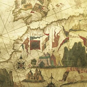
This photograph print depicts a map of Morocco during the Spanish War of Africa (1859-1860), displayed in a museum in Donostia, Spain. The map, richly colored and adorned with intricate cartographic details, is a testament to the historical significance of this period in African and Spanish history. The focus of the image, however, is not solely on the map itself, but also on the surrounding context. Scattered around the map are various pieces of African rubbish and trash, adding an unexpected layer of contrast and complexity to the scene. The Moroccan cartographies, with their intricate patterns and vibrant colors, juxtaposed against the mundane and discarded waste, create a striking visual dialogue. The sanitation and waste management practices of the time are reflected in this image, offering a glimpse into the daily life of the people during this era. The map, with its detailed municipal divisions and annotations, highlights the Spanish influence and control over Moroccan territories during the war. The cartographic representation of the region is a powerful tool that reveals the political and strategic interests of the Spanish during this period. The photograph print, with its vivid colors and intriguing juxtaposition, invites viewers to explore the complex history of Spain's involvement in Africa and the role of cartography in shaping our understanding of the world.
MADE IN THE USA
Safe Shipping with 30 Day Money Back Guarantee
FREE PERSONALISATION*
We are proud to offer a range of customisation features including Personalised Captions, Color Filters and Picture Zoom Tools
SECURE PAYMENTS
We happily accept a wide range of payment options so you can pay for the things you need in the way that is most convenient for you
* Options may vary by product and licensing agreement. Zoomed Pictures can be adjusted in the Cart.