Jigsaw Puzzle > South America > Brazil > Maps
Jigsaw Puzzle : Map /s America / Brazil 16C


![]()
Jigsaw Puzzles from Mary Evans Picture Library
Map /s America / Brazil 16C
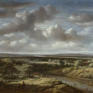
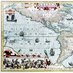
Map of Brazil
Mary Evans Picture Library makes available wonderful images created for people to enjoy over the centuries
Media ID 582578
© Mary Evans Picture Library 2015 - https://copyrighthub.org/s0/hub1/creation/maryevans/MaryEvansPictureID/10030239
Jigsaw Puzzle (520 Pieces)
Discover the rich history of Brazil with our captivating jigsaw puzzle from the Media Storehouse collection. This intricately designed puzzle features a vintage map of Brazil from the 16th century, as obtained from Mary Evans Picture Library via Mary Evans Prints Online. Immerse yourself in the exploration and discovery of this fascinating country as you piece together this detailed and beautiful puzzle. Perfect for puzzle enthusiasts, history buffs, or anyone looking for a challenging and engaging activity. Enjoy the journey of unraveling the past, one puzzle piece at a time.
Made in the USA, 520-piece puzzles measure 16" x 20" (40.6 x 50.8 cm). Every puzzle is meticulously printed on glossy photo paper, which has a strong 1.33 mm thickness. Delivered in a black storage cardboard box, these puzzles are both stylish and practical. (Note: puzzles contain small parts and are not suitable for children under 3 years of age.)
Jigsaw Puzzles are an ideal gift for any occasion
Estimated Product Size is 50.8cm x 40.5cm (20" x 15.9")
These are individually made so all sizes are approximate
Artwork printed orientated as per the preview above, with landscape (horizontal) or portrait (vertical) orientation to match the source image.
FEATURES IN THESE COLLECTIONS
> Maps and Charts
> Early Maps
> Maps and Charts
> Related Images
> South America
> Brazil
> Maps
> South America
> Brazil
> Related Images
> South America
> Related Images
> Mary Evans Prints Online
> Maps
EDITORS COMMENTS
This stunning print captures a piece of history with the detailed map of Brazil from the 16th century. The intricate lines and markings on the map provide a glimpse into what the country looked like over four centuries ago. From the coastal cities to the vast interior regions, this map showcases Brazil's diverse geography and rich history.
Created in 1582, this historical artifact offers a unique perspective on South America during this time period. It serves as a reminder of the explorers who first mapped out these lands and paved the way for future generations. The attention to detail in this map is truly remarkable, showcasing rivers, mountains, and settlements with precision.
As we gaze upon this piece from Mary Evans Picture Library, we are transported back in time to an era of discovery and exploration. The colors may have faded slightly over time, but the significance of this map remains intact. It is a testament to human ingenuity and curiosity about our world.
Whether you are a history buff or simply appreciate fine artistry, this Map of Brazil from the 16th century is sure to captivate your imagination. Display it proudly in your home or office as a conversation starter and a tribute to Brazil's fascinating past.
MADE IN THE USA
Safe Shipping with 30 Day Money Back Guarantee
FREE PERSONALISATION*
We are proud to offer a range of customisation features including Personalised Captions, Color Filters and Picture Zoom Tools
SECURE PAYMENTS
We happily accept a wide range of payment options so you can pay for the things you need in the way that is most convenient for you
* Options may vary by product and licensing agreement. Zoomed Pictures can be adjusted in the Cart.