Canvas Print > South America > Brazil > Maps
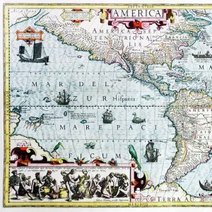
Canvas Print : Map /s America / Brazil 16C


![]()
Canvas Prints from Mary Evans Picture Library
Map /s America / Brazil 16C
Map of Brazil
Mary Evans Picture Library makes available wonderful images created for people to enjoy over the centuries
Media ID 582578
© Mary Evans Picture Library 2015 - https://copyrighthub.org/s0/hub1/creation/maryevans/MaryEvansPictureID/10030239
20"x16" (51x41cm) Canvas Print
Introducing the captivating addition to our Media Storehouse Canvas Prints collection: "Map /s America / Brazil 16C" by Mary Evans Picture Library. This exquisite piece, sourced from Mary Evans Prints Online, transports you back in time with an intricately detailed map of Brazil from the 16th century. Each canvas print is meticulously crafted using premium materials and high-definition printing techniques, ensuring a stunningly vibrant and sharp representation of the historical cartography. Bring the rich history of Brazil into your home or office with this beautiful and conversation-starting work of art.
Delivered stretched and ready to hang our premium quality canvas prints are made from a polyester/cotton blend canvas and stretched over a 1.25" (32mm) kiln dried knot free wood stretcher bar. Packaged in a plastic bag and secured to a cardboard insert for safe transit.
Canvas Prints add colour, depth and texture to any space. Professionally Stretched Canvas over a hidden Wooden Box Frame and Ready to Hang
Estimated Product Size is 50.8cm x 40.6cm (20" x 16")
These are individually made so all sizes are approximate
Artwork printed orientated as per the preview above, with landscape (horizontal) orientation to match the source image.
FEATURES IN THESE COLLECTIONS
> Maps and Charts
> Early Maps
> Maps and Charts
> Related Images
> South America
> Brazil
> Maps
> South America
> Brazil
> Related Images
> South America
> Related Images
> Mary Evans Prints Online
> Maps
EDITORS COMMENTS
This stunning print captures a piece of history with the detailed map of Brazil from the 16th century. The intricate lines and markings on the map provide a glimpse into what the country looked like over four centuries ago. From the coastal cities to the vast interior regions, this map showcases Brazil's diverse geography and rich history.
Created in 1582, this historical artifact offers a unique perspective on South America during this time period. It serves as a reminder of the explorers who first mapped out these lands and paved the way for future generations. The attention to detail in this map is truly remarkable, showcasing rivers, mountains, and settlements with precision.
As we gaze upon this piece from Mary Evans Picture Library, we are transported back in time to an era of discovery and exploration. The colors may have faded slightly over time, but the significance of this map remains intact. It is a testament to human ingenuity and curiosity about our world.
Whether you are a history buff or simply appreciate fine artistry, this Map of Brazil from the 16th century is sure to captivate your imagination. Display it proudly in your home or office as a conversation starter and a tribute to Brazil's fascinating past.
MADE IN THE USA
Safe Shipping with 30 Day Money Back Guarantee
FREE PERSONALISATION*
We are proud to offer a range of customisation features including Personalised Captions, Color Filters and Picture Zoom Tools
SECURE PAYMENTS
We happily accept a wide range of payment options so you can pay for the things you need in the way that is most convenient for you
* Options may vary by product and licensing agreement. Zoomed Pictures can be adjusted in the Cart.