Jigsaw Puzzle > Historic > Ancient civilizations > Roman Empire > Roman art
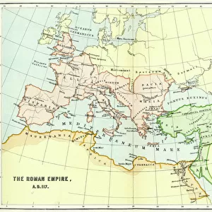
Jigsaw Puzzle : Map of the Roman Empire


Jigsaw Puzzles from Mary Evans Picture Library
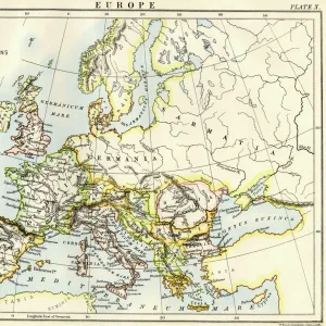
Map of the Roman Empire
A map showing the extent of the Roman Empire
Mary Evans Picture Library makes available wonderful images created for people to enjoy over the centuries
Media ID 600232
© Mary Evans Picture Library 2015 - https://copyrighthub.org/s0/hub1/creation/maryevans/MaryEvansPictureID/10137105
Civilisation Conquest Control Extensive Extent Maps Romans
Jigsaw Puzzle (1014 Pieces)
Discover the rich history and intricate details of the ancient Roman Empire with our captivating jigsaw puzzles from Media Storehouse. Featuring the stunning "Map of the Roman Empire" by Mary Evans Picture Library, this puzzle invites you on a journey through time as you piece together the vast expanse of the empire's reach. With meticulously reproduced imagery from Mary Evans Prints Online, the puzzle pieces bring the map's intricate lines and borders to life. Immerse yourself in the historical significance and beauty of this iconic representation of the Roman Empire. Ideal for history enthusiasts, puzzle lovers, and families, this challenging yet rewarding puzzle is a must-have addition to your collection.
Made in the USA, 1014-piece puzzles measure 20" x 30" (50.8 x 76.2 cm). Every puzzle is meticulously printed on glossy photo paper, which has a strong 1.33 mm thickness. Delivered in a black storage cardboard box, these puzzles are both stylish and practical. (Note: puzzles contain small parts and are not suitable for children under 3 years of age.)
Jigsaw Puzzles are an ideal gift for any occasion
Estimated Product Size is 76cm x 50.8cm (29.9" x 20")
These are individually made so all sizes are approximate
Artwork printed orientated as per the preview above, with landscape (horizontal) orientation to match the source image.
FEATURES IN THESE COLLECTIONS
> Arts
> Artists
> R
> Roman Roman
> Europe
> Related Images
> Historic
> Ancient civilizations
> Roman Empire
> Roman art
> Maps and Charts
> Early Maps
> Maps and Charts
> Related Images
EDITORS COMMENTS
This stunning print of a Map of the Roman Empire offers a fascinating glimpse into the extent of one of history's most powerful civilizations. Dating back to the 2nd century, this historical map showcases the vast conquests and control achieved by the Romans across Europe and beyond. The intricate details on display highlight not only the sheer size of their empire but also the sophistication and organization that allowed them to maintain such extensive territories.
As we study this map, we can't help but marvel at how far-reaching Roman influence was during this era. From Britain to North Africa, from Spain to Asia Minor, every corner of their empire is meticulously depicted, showcasing just how advanced their civilization was in terms of military strategy, governance, and cultural assimilation.
Through maps like these, we are able to connect with our past in a tangible way, gaining insight into the complexities and achievements of ancient societies. This particular print from Mary Evans Picture Library serves as a valuable educational tool for historians and enthusiasts alike who wish to delve deeper into understanding the legacy left behind by one of history's greatest empires.
MADE IN THE USA
Safe Shipping with 30 Day Money Back Guarantee
FREE PERSONALISATION*
We are proud to offer a range of customisation features including Personalised Captions, Color Filters and Picture Zoom Tools
SECURE PAYMENTS
We happily accept a wide range of payment options so you can pay for the things you need in the way that is most convenient for you
* Options may vary by product and licensing agreement. Zoomed Pictures can be adjusted in the Cart.