Jigsaw Puzzle > Maps and Charts > Turkey
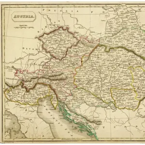
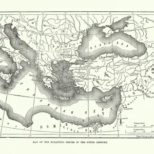
Jigsaw Puzzle : Map / Europe / Balkans 1792


![]()
Jigsaw Puzzles from Mary Evans Picture Library
Map / Europe / Balkans 1792
A map showing Turkey in Europe and its neighbouring European states of the Balkans
Mary Evans Picture Library makes available wonderful images created for people to enjoy over the centuries
Media ID 620825
© Mary Evans Picture Library 2015 - https://copyrighthub.org/s0/hub1/creation/maryevans/MaryEvansPictureID/10074527
1792 Balkans Maps Neighbouring
Jigsaw Puzzle (520 Pieces)
Discover the rich history and intricate geography of the European Balkans in 1792 with our captivating jigsaw puzzle from Media Storehouse, in partnership with Mary Evans Prints Online. This beautifully detailed puzzle features an antique map depicting Turkey in Europe and its neighboring European states, providing an educational and engaging experience for puzzle enthusiasts of all ages. Immerse yourself in the history of this fascinating region, and enjoy the satisfaction of piecing together this intricately designed puzzle. A perfect addition to any home or classroom, this puzzle is not only a fun activity but also a beautiful decorative piece.
Made in the USA, 520-piece puzzles measure 16" x 20" (40.6 x 50.8 cm). Every puzzle is meticulously printed on glossy photo paper, which has a strong 1.33 mm thickness. Delivered in a black storage cardboard box, these puzzles are both stylish and practical. (Note: puzzles contain small parts and are not suitable for children under 3 years of age.)
Jigsaw Puzzles are an ideal gift for any occasion
Estimated Product Size is 50.8cm x 40.5cm (20" x 15.9")
These are individually made so all sizes are approximate
Artwork printed orientated as per the preview above, with landscape (horizontal) or portrait (vertical) orientation to match the source image.
FEATURES IN THESE COLLECTIONS
> Asia
> Turkey
> Related Images
> Europe
> Related Images
> Maps and Charts
> Early Maps
> Maps and Charts
> Related Images
EDITORS COMMENTS
This historical map print from 1792 showcases the intricate borders and political landscape of Europe, specifically focusing on the Balkans region and Turkey in Europe. The detailed cartography highlights the neighboring European states surrounding Turkey, providing a glimpse into the complex history and territorial divisions of the time.
The map offers a fascinating insight into the geopolitical dynamics of Europe during this period, with each country clearly delineated and labeled for easy reference. From Hungary to Greece, Serbia to Bulgaria, every nation is represented on this meticulously crafted piece of historical artwork.
As we study this map, we are transported back in time to an era when empires clashed and alliances shifted constantly. The intricate details and fine craftsmanship of the map serve as a testament to the skill and dedication of cartographers from centuries past.
Whether you are a history buff or simply appreciate fine artistry, this vintage map print is sure to captivate your imagination and spark curiosity about the rich tapestry of European history. Display it proudly in your home or office as a conversation piece that will inspire discussion about our shared past and how it has shaped our present-day world.
MADE IN THE USA
Safe Shipping with 30 Day Money Back Guarantee
FREE PERSONALISATION*
We are proud to offer a range of customisation features including Personalised Captions, Color Filters and Picture Zoom Tools
SECURE PAYMENTS
We happily accept a wide range of payment options so you can pay for the things you need in the way that is most convenient for you
* Options may vary by product and licensing agreement. Zoomed Pictures can be adjusted in the Cart.