Jigsaw Puzzle > Europe > Italy > Maps
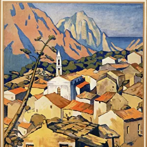
Jigsaw Puzzle : Map of Corsica. Italian engraving. 16th century


![]()
Jigsaw Puzzles from Mary Evans Picture Library
Map of Corsica. Italian engraving. 16th century
Mary Evans Picture Library makes available wonderful images created for people to enjoy over the centuries
Media ID 14337095
© Thaliastock / Mary Evans
Cartography Corsica Geography Mediterranean
Jigsaw Puzzle (1014 Pieces)
Discover the rich history of Corsica with our exquisite jigsaw puzzle from Media Storehouse. Featuring a stunning 16th century Italian engraving of a map of the island from Mary Evans Prints Online, this puzzle is a must-have for history enthusiasts and puzzle lovers alike. Immerse yourself in the intricate details of this captivating map, transporting you back in time to the Italian Renaissance era. With carefully selected pieces and vibrant colors, this puzzle promises an engaging and rewarding experience. Get ready to piece together the past and create a beautiful display in your home.
Made in the USA, 1014-piece puzzles measure 20" x 30" (50.8 x 76.2 cm). Every puzzle is meticulously printed on glossy photo paper, which has a strong 1.33 mm thickness. Delivered in a black storage cardboard box, these puzzles are both stylish and practical. (Note: puzzles contain small parts and are not suitable for children under 3 years of age.)
Jigsaw Puzzles are an ideal gift for any occasion
Estimated Product Size is 50.8cm x 76cm (20" x 29.9")
These are individually made so all sizes are approximate
Artwork printed orientated as per the preview above, with portrait (vertical) orientation to match the source image.
FEATURES IN THESE COLLECTIONS
> Maps and Charts
> Early Maps
> Maps and Charts
> Italy
> Maps and Charts
> Related Images
EDITORS COMMENTS
16th Century Italian Engraving: A Vintage Glimpse into the Cartography of Corsica This exquisite 16th century Italian engraving presents a captivating and intricately detailed view of the Mediterranean island of Corsica. Dating back to an era when cartography was in its infancy, this map offers a fascinating glimpse into the geographical knowledge and artistic sensibilities of the time. The map, depicting Corsica's rugged coastline, mountainous interior, and surrounding waters, is a testament to the meticulous efforts of the cartographers of the age. The intricate engraving technique, popular during the Renaissance period, is evident in the finely etched lines and the delicate shading that brings the topography to life. Corsica, an island located in the Mediterranean Sea, has a rich and complex history. Belonging to France since 1769, it was previously ruled by various European powers, including the Genoese and the Spanish. This Italian engraving, produced during a time when Corsica was under Genoese rule, reflects the island's strategic importance in Mediterranean trade and politics. The map also reveals the European perspective of the world during the Modern Age. With its emphasis on precise geographical information and artistic representation, this map serves as an essential record of the era's cartographic achievements. It is a reminder of the role that maps played in shaping our understanding of the world and the cultural exchanges that took place during the 16th century. In conclusion, this 16th century Italian engraving of Corsica is a valuable historical artifact that offers a unique perspective on the geography, politics, and artistic sensibilities of the time. Its intricate details and meticulous craftsmanship make it a captivating addition to any collection of vintage maps or European history.
MADE IN THE USA
Safe Shipping with 30 Day Money Back Guarantee
FREE PERSONALISATION*
We are proud to offer a range of customisation features including Personalised Captions, Color Filters and Picture Zoom Tools
SECURE PAYMENTS
We happily accept a wide range of payment options so you can pay for the things you need in the way that is most convenient for you
* Options may vary by product and licensing agreement. Zoomed Pictures can be adjusted in the Cart.