Jigsaw Puzzle : Map of the Belgian frontier with forts, World War One


![]()
Jigsaw Puzzles From Mary Evans Picture Library
Map of the Belgian frontier with forts, World War One
Map of the Belgian frontier with forts at the beginning of World War One. Date: 1914
Mary Evans Picture Library makes available wonderful images created for people to enjoy over the centuries
Media ID 14125874
© Mary Evans Picture Library/PHILIP TALMAGE
Belgian Countries Forts Frontier Holland Maps
Jigsaw Puzzle (1014 Pieces)
Discover the historical depth of our "Map of the Belgian Frontier with Forts, World War One" jigsaw puzzle from Media Storehouse. This captivating puzzle, featuring an authentic map from 1914 obtained from Mary Evans Prints Online, transports you back in time to the beginning of a significant era. With intricately detailed forts and borders, this puzzle promises an immersive experience. Assemble this puzzle to learn more about the geopolitical landscape of the early 20th century while engaging in a fun and educational activity. Immerse yourself in history with the Media Storehouse "Map of the Belgian Frontier with Forts, World War One" jigsaw puzzle.
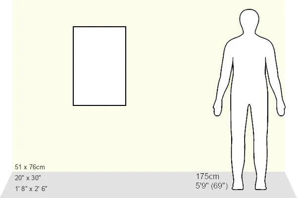
Made in the USA, 1014-piece puzzles measure 20" x 30" (50.8 x 76.2 cm). Every puzzle is meticulously printed on glossy photo paper, which has a strong 1.33 mm thickness. Delivered in a black storage cardboard box, these puzzles are both stylish and practical. (Note: puzzles contain small parts and are not suitable for children under 3 years of age.)
Jigsaw Puzzles are an ideal gift for any occasion
Estimated Product Size is 50.8cm x 76cm (20" x 29.9")
These are individually made so all sizes are approximate
Artwork printed orientated as per the preview above, with portrait (vertical) orientation to match the source image.
EDITORS COMMENTS
This historic map print depicts the Belgian frontier at the onset of World War One in 1914. The intricate detailing highlights the strategic fortifications along the border, which played a pivotal role in the early stages of the war. The map illustrates the complex web of alliances and territories in Europe during this tumultuous period. At the center of the map, the Belgian fortifications, including the strongholds of Liege, Namur, and Antwerp, are clearly marked. These fortifications were designed to protect Belgium from external threats and were considered some of the most advanced and impregnable in Europe at the time. However, they were ultimately breached by German forces in August 1914, marking a significant turning point in the war. The map also shows the neighboring countries of France, Germany, and Holland, emphasizing the interconnectedness of Europe's political landscape. The intricate border lines and annotations provide a glimpse into the complex web of alliances and tensions that fueled the outbreak of war. This map offers a unique perspective on the geopolitical situation in Europe at the beginning of World War One, providing valuable context for understanding the events that unfolded during this pivotal period in history. The intricate detailing and historical significance make this map a fascinating addition to any collection of World War One memorabilia or European history.
MADE IN THE USA
Safe Shipping with 30 Day Money Back Guarantee
FREE PERSONALISATION*
We are proud to offer a range of customisation features including Personalised Captions, Color Filters and Picture Zoom Tools
SECURE PAYMENTS
We happily accept a wide range of payment options so you can pay for the things you need in the way that is most convenient for you
* Options may vary by product and licensing agreement. Zoomed Pictures can be adjusted in the Basket.