Jigsaw Puzzle > Europe > Republic of Ireland > Cork
Jigsaw Puzzle : Ireland / Cork / 1633 Map


![]()
Jigsaw Puzzles from Mary Evans Picture Library
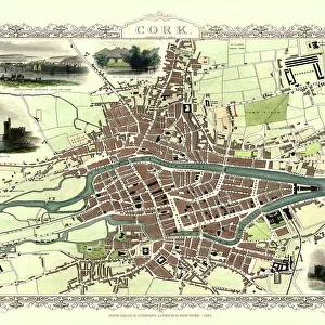
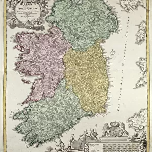
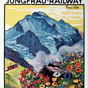
Ireland / Cork / 1633 Map
Primitive relief map of the city
Mary Evans Picture Library makes available wonderful images created for people to enjoy over the centuries
Media ID 4324917
© Mary Evans Picture Library 2015 - https://copyrighthub.org/s0/hub1/creation/maryevans/MaryEvansPictureID/10026009
Jigsaw Puzzle (520 Pieces)
Discover the rich history of Ireland with our captivating jigsaw puzzle from the Media Storehouse collection. This intriguing puzzle features a primitive relief map of Cork, as it appeared in the year 1633. Meticulously sourced from Mary Evans Prints Online, this Rights Managed image offers an authentic glimpse into the past. Piece together the vibrant, historical details of this ancient city, and immerse yourself in the fascinating tales that lie within. A perfect activity for history enthusiasts, puzzle lovers, or anyone seeking a fun and engaging way to learn about Ireland's rich heritage.
Made in the USA, 520-piece puzzles measure 16" x 20" (40.6 x 50.8 cm). Every puzzle is meticulously printed on glossy photo paper, which has a strong 1.33 mm thickness. Delivered in a black storage cardboard box, these puzzles are both stylish and practical. (Note: puzzles contain small parts and are not suitable for children under 3 years of age.)
Jigsaw Puzzles are an ideal gift for any occasion
Estimated Product Size is 40.5cm x 50.8cm (15.9" x 20")
These are individually made so all sizes are approximate
Artwork printed orientated as per the preview above, with landscape (horizontal) or portrait (vertical) orientation to match the source image.
FEATURES IN THESE COLLECTIONS
> Europe
> Republic of Ireland
> Cork
> Europe
> Republic of Ireland
> Maps
> Maps and Charts
> Early Maps
> Maps and Charts
> Related Images
EDITORS COMMENTS
This stunning print captures a piece of history with an intricate map of Cork, Ireland from the year 1633. The primitive relief map showcases the city in incredible detail, highlighting its streets, buildings, and natural features. This historical artifact provides a fascinating glimpse into what Cork looked like over three centuries ago.
The texture of the relief map adds depth and dimension to the image, making it feel almost tangible as if you could reach out and touch the cityscape. The walls surrounding Cork are clearly delineated, giving insight into how the city was fortified during this time period.
As you study this map closely, you can imagine what life was like in Cork in 1633 - bustling markets, busy streets filled with merchants and traders, and ships coming in and out of the harbor. It's a snapshot frozen in time that allows us to connect with the past and appreciate how much has changed since then.
Whether you have a personal connection to Cork or simply appreciate history and cartography, this print is sure to captivate your imagination. Display it proudly on your wall as a conversation piece that will spark curiosity and admiration for centuries-old craftsmanship.
MADE IN THE USA
Safe Shipping with 30 Day Money Back Guarantee
FREE PERSONALISATION*
We are proud to offer a range of customisation features including Personalised Captions, Color Filters and Picture Zoom Tools
SECURE PAYMENTS
We happily accept a wide range of payment options so you can pay for the things you need in the way that is most convenient for you
* Options may vary by product and licensing agreement. Zoomed Pictures can be adjusted in the Cart.