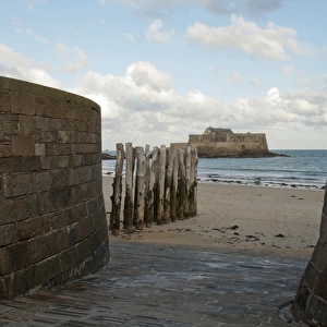
Jigsaw Puzzle : 1852, Levasseur Map of the Department Cotes Du Nord, Brittany, France, topography


![]()
Jigsaw Puzzles From Liszt Collection
1852, Levasseur Map of the Department Cotes Du Nord, Brittany, France, topography
1852, Levasseur Map of the Department Cotes Du Nord, Brittany, France
Liszt Collection of nineteenth-century engravings and images to browse and enjoy
Media ID 14005235
© Artokoloro Quint Lox Limited
1852 Brittany Antique Map Latitude Longitude Mappa Mundi Old Antique Plan Old Antique View Ols Antique Map Rare Old Maps Topo
Jigsaw Puzzle (520 Pieces)
Discover the rich history and intricate beauty of Brittany, France with our exquisite 1852 Levasseur Map of the Department Cotes Du Nord jigsaw puzzle. This captivating puzzle, sourced from the esteemed Liszt Collection, invites you to piece together the topography of this stunning region. Immerse yourself in the detailed depiction of the rolling hills, winding rivers, and quaint villages of Cotes Du Nord. A perfect addition to any home or office, this challenging yet rewarding puzzle is a must-have for history enthusiasts, puzzle lovers, and anyone seeking a moment of relaxation and mindfulness. Engage in a journey of discovery and create a tangible connection with the past as you bring this piece of history to life, one puzzle piece at a time.
Made in the USA, 520-piece puzzles measure 16" x 20" (40.6 x 50.8 cm). Every puzzle is meticulously printed on glossy photo paper, which has a strong 1.33 mm thickness. Delivered in a black storage cardboard box, these puzzles are both stylish and practical. (Note: puzzles contain small parts and are not suitable for children under 3 years of age.)
Jigsaw Puzzles are an ideal gift for any occasion
Estimated Product Size is 50.8cm x 40.5cm (20" x 15.9")
These are individually made so all sizes are approximate
Artwork printed orientated as per the preview above, with landscape (horizontal) or portrait (vertical) orientation to match the source image.
EDITORS COMMENTS
This print showcases the intricate details of the 1852 Levasseur Map of the Department Cotes Du Nord in Brittany, France. A true testament to the artistry and precision of cartography, this topographical map offers a glimpse into the geographic landscape of this historic region. The carefully illustrated contours and landmarks depicted on this vintage map transport us back in time, allowing us to explore and appreciate the rich history that lies within its borders. With its grid-like structure, latitude and longitude lines, and geometric accuracy, it serves as both a navigational tool and a work of art. As we gaze upon this aged piece of paper, we are reminded of how maps have played an integral role in our journey of discovery and exploration throughout history. This rare antique map not only provides valuable insights into past civilizations but also evokes a sense of wonder about our place in the world. With its decorative elements and historical significance, this Levasseur Map is more than just a geographical representation; it is a window into another era. It invites us to embark on an imaginary voyage through time as we trace ancient trade routes or envision what life was like for those who once inhabited these lands. Whether you are an avid collector or simply fascinated by old maps, this exquisite print from Liszt Collection brings together artistry, history, and geography in one stunning visual display.
MADE IN THE USA
Safe Shipping with 30 Day Money Back Guarantee
FREE PERSONALISATION*
We are proud to offer a range of customisation features including Personalised Captions, Color Filters and Picture Zoom Tools
SECURE PAYMENTS
We happily accept a wide range of payment options so you can pay for the things you need in the way that is most convenient for you
* Options may vary by product and licensing agreement. Zoomed Pictures can be adjusted in the Basket.