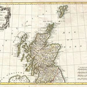
Jigsaw Puzzle : 1799, Clement Cruttwell Map of Scotland, topography, cartography, geography, land


![]()
Jigsaw Puzzles From Liszt Collection
1799, Clement Cruttwell Map of Scotland, topography, cartography, geography, land
1799, Clement Cruttwell Map of Scotland
Liszt Collection of nineteenth-century engravings and images to browse and enjoy
Media ID 14006934
© Artokoloro Quint Lox Limited
1799 Antique Map Latitude Longitude Mappa Mundi Old Antique Plan Old Antique View Ols Antique Map Rare Old Maps Topo
Jigsaw Puzzle (520 Pieces)
"Discover the rich history and intricate details of Scotland with our stunning jigsaw puzzle from the Media Storehouse Collection. Featuring the 1799 Clement Cruttwell Map of Scotland from the Liszt Collection, this puzzle brings the topography, cartography, and geography of this beautiful country to life. Immerse yourself in the exploration of Scotland's landscapes and landmarks, all while enjoying the satisfying experience of piecing together this captivating puzzle. A perfect activity for puzzle enthusiasts, history buffs, or anyone looking to expand their knowledge and appreciation for the wonders of Scotland."
Made in the USA, 520-piece puzzles measure 16" x 20" (40.6 x 50.8 cm). Every puzzle is meticulously printed on glossy photo paper, which has a strong 1.33 mm thickness. Delivered in a black storage cardboard box, these puzzles are both stylish and practical. (Note: puzzles contain small parts and are not suitable for children under 3 years of age.)
Jigsaw Puzzles are an ideal gift for any occasion
Estimated Product Size is 40.5cm x 50.8cm (15.9" x 20")
These are individually made so all sizes are approximate
Artwork printed orientated as per the preview above, with landscape (horizontal) or portrait (vertical) orientation to match the source image.
EDITORS COMMENTS
This print showcases the remarkable "1799, Clement Cruttwell Map of Scotland" a true masterpiece in topography, cartography, and geography. With meticulous attention to detail, this vintage map offers an immersive journey into the land's rich history and ancient charm. The illustration is a testament to the artistry involved in creating such maps during that era. Its intricate grid system, latitude and longitude markings, and geometric precision make it not only a valuable tool for navigation but also a decorative piece of historical significance. As we gaze upon this aged treasure, we are transported back in time to an age of exploration and discovery. The map's faded colors evoke nostalgia while reminding us of its enduring relevance as a geographic reference point. Every corner of Scotland is meticulously depicted on this rare antique map – from its majestic highlands to its picturesque coastal regions. It serves as both a window into the past and an invitation to explore this enchanting region further. Whether you are an avid collector or simply appreciate the beauty of old maps, this print from Liszt Collection is sure to captivate your imagination. Let it transport you through time as you marvel at the craftsmanship that went into creating such exquisite pieces of cartographic artistry.
MADE IN THE USA
Safe Shipping with 30 Day Money Back Guarantee
FREE PERSONALISATION*
We are proud to offer a range of customisation features including Personalised Captions, Color Filters and Picture Zoom Tools
SECURE PAYMENTS
We happily accept a wide range of payment options so you can pay for the things you need in the way that is most convenient for you
* Options may vary by product and licensing agreement. Zoomed Pictures can be adjusted in the Basket.