Jigsaw Puzzle > Europe > Finland > Related Images
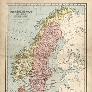
Jigsaw Puzzle : 1794, Laurie and Whittle Map of Norway, Sweden, Denmark and Finland, 1794 - 1812


![]()
Jigsaw Puzzles From Liszt Collection
1794, Laurie and Whittle Map of Norway, Sweden, Denmark and Finland, 1794 - 1812
Liszt Collection of nineteenth-century engravings and images to browse and enjoy
Media ID 14004835
© Artokoloro Quint Lox Limited
1794 Sweden 1794 1812 Antique Map Latitude Longitude Mappa Mundi Old Antique Plan Old Antique View Ols Antique Map Rare Old Maps Topo
Jigsaw Puzzle (520 Pieces)
Discover the historical beauty of Europe with our exquisite jigsaw puzzle from Media Storehouse. Featuring the 1794 Laurie and Whittle Map of Norway, Sweden, Denmark, and Finland from the Liszt Collection, this puzzle takes you on a journey through time. Explore intricate details of the map, depicting the borders and geographical features of these Scandinavian countries during the late 18th and early 19th centuries. Assemble this captivating puzzle to create a stunning piece of art for your home, and immerse yourself in the rich history of the region.
Made in the USA, 520-piece puzzles measure 16" x 20" (40.6 x 50.8 cm). Every puzzle is meticulously printed on glossy photo paper, which has a strong 1.33 mm thickness. Delivered in a black storage cardboard box, these puzzles are both stylish and practical. (Note: puzzles contain small parts and are not suitable for children under 3 years of age.)
Jigsaw Puzzles are an ideal gift for any occasion
Estimated Product Size is 50.8cm x 40.5cm (20" x 15.9")
These are individually made so all sizes are approximate
Artwork printed orientated as per the preview above, with landscape (horizontal) or portrait (vertical) orientation to match the source image.
EDITORS COMMENTS
This print showcases the exquisite "1794, Laurie and Whittle Map of Norway, Sweden, Denmark and Finland". A true masterpiece of cartography, this vintage map takes us on a journey through time to the early 19th century. With its intricate details and meticulous craftsmanship, it offers a glimpse into the world as it was over two centuries ago. The topography is beautifully depicted, revealing the diverse landscapes of these Nordic countries. From majestic mountains to serene fjords and sprawling forests, every contour is carefully illustrated. The grid lines indicate latitude and longitude coordinates with geometric precision, allowing for accurate navigation across these lands. As we explore this historical gem further, we are transported back in time to an era when exploration and discovery were at their peak. This old map serves as a window into the past – an invaluable resource for historians and enthusiasts alike. Printed on aged paper with an artistic touch that adds to its charm, this decorative piece captures both the artistry and functionality of maps from bygone eras. It reminds us of our connection to history while igniting our curiosity about how these regions have evolved over time. Whether displayed in a study or cherished as part of a collection dedicated to antique maps, this rare find from the Liszt Collection brings together geography, artistry, and history in one captivating image.
MADE IN THE USA
Safe Shipping with 30 Day Money Back Guarantee
FREE PERSONALISATION*
We are proud to offer a range of customisation features including Personalised Captions, Color Filters and Picture Zoom Tools
SECURE PAYMENTS
We happily accept a wide range of payment options so you can pay for the things you need in the way that is most convenient for you
* Options may vary by product and licensing agreement. Zoomed Pictures can be adjusted in the Basket.