Jigsaw Puzzle > North America > United States of America > New York > New York > Maps
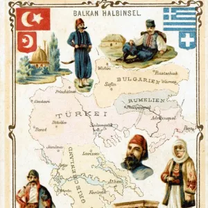
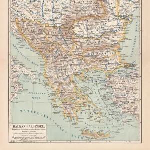
Jigsaw Puzzle : War map of the Balkan States. Artist: Joseph Koehler, Publisher, New York (active 1892-1913)
")
")


![]()
Jigsaw Puzzles From Heritage Images
War map of the Balkan States. Artist: Joseph Koehler, Publisher, New York (active 1892-1913)
War map of the Balkan States. Private Collection
Heritage Images features heritage image collections
Media ID 15017932
© Fine Art Images
Balkan Balkan War Cartography Publisher The United States Balkan Wars Colour Lithograph
Jigsaw Puzzle (520 Pieces)
Discover history through the intriguing challenge of our Media Storehouse Jigsaw Puzzles. This captivating puzzle, featuring a vintage war map of the Balkan States from the early 20th century, is a must-have for history enthusiasts and puzzle lovers alike. Originally created by renowned artist and publisher Joseph Koehler in New York between 1892 and 1913, this detailed and historically significant map will transport you back in time. Assemble the pieces to reveal the complex political landscape of the Balkan region during a pivotal historical period. Engage your mind, connect the past with the present, and create a beautiful and meaningful display piece. The perfect addition to any home office, den, or study, this jigsaw puzzle is not just a pastime, but an educational and enjoyable experience.
Made in the USA, 520-piece puzzles measure 16" x 20" (40.6 x 50.8 cm). Every puzzle is meticulously printed on glossy photo paper, which has a strong 1.33 mm thickness. Delivered in a black storage cardboard box, these puzzles are both stylish and practical. (Note: puzzles contain small parts and are not suitable for children under 3 years of age.)
Jigsaw Puzzles are an ideal gift for any occasion
Estimated Product Size is 50.8cm x 40.5cm (20" x 15.9")
These are individually made so all sizes are approximate
Artwork printed orientated as per the preview above, with landscape (horizontal) or portrait (vertical) orientation to match the source image.
FEATURES IN THESE COLLECTIONS
> Maps and Charts
> Related Images
> North America
> United States of America
> New York
> New York
> Maps
EDITORS COMMENTS
This print showcases a remarkable piece of cartography titled "War map of the Balkan States" created by the talented artist Joseph Koehler and published in New York between 1892 and 1913. The image, now part of a private collection, offers a glimpse into an era marked by conflict and historical significance. The vibrant colors of this fine art lithograph bring to life the intricate details that make up the Balkan region. With precision and skill, Koehler meticulously depicts the geographical boundaries and political divisions during a tumultuous period known for its wars. As we delve into history through this artwork, we are transported back to a time when tensions ran high in the Balkans. From the first Balkan War to subsequent conflicts like the Second Balkan War, these maps serve as invaluable tools for understanding how borders shifted and alliances were formed. Joseph Koehler's work not only serves as an educational resource but also stands as a testament to his talent as both an artist and publisher. His dedication to capturing historical events through vivid imagery is evident in every brushstroke. This photograph print from Heritage Images allows us to appreciate not only the artistic merit but also the historical importance of this unique piece. It reminds us that even within private collections, there are treasures waiting to be discovered – windows into our past that continue to shape our present understanding of global events.
MADE IN THE USA
Safe Shipping with 30 Day Money Back Guarantee
FREE PERSONALISATION*
We are proud to offer a range of customisation features including Personalised Captions, Color Filters and Picture Zoom Tools
SECURE PAYMENTS
We happily accept a wide range of payment options so you can pay for the things you need in the way that is most convenient for you
* Options may vary by product and licensing agreement. Zoomed Pictures can be adjusted in the Basket.