Jigsaw Puzzle > Arts > Artists > O > Oceanic Oceanic
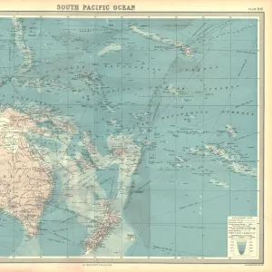
Jigsaw Puzzle : Map of the South Pacific Ocean


![]()
Jigsaw Puzzles From Heritage Images
Map of the South Pacific Ocean
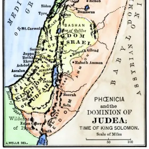
Map of the South Pacific Ocean. Map showing the Philippines, Indonesia, Papua New Guinea, Australia and New Zealand, and Pacific islands. Plate 102 from The Times Atlas
Heritage Images features heritage image collections
Media ID 15464878
© The Print Collector / Heritage-Images
Australasia Australia Cartography Indonesia Island Islands Map Making New Zealand Oceania Pacific Ocean Papua New Guinea Philippines South Pacific
Jigsaw Puzzle (520 Pieces)
Discover the wonders of the South Pacific with our captivating jigsaw puzzles from Media Storehouse. This intricately detailed puzzle, featuring Plate 102 from The Times Atlas, showcases the breathtaking beauty of the South Pacific Ocean. Explore the vibrant waters surrounding the Philippines, Indonesia, Papua New Guinea, Australia, New Zealand, and numerous Pacific islands. Engage your mind and ignite your sense of adventure as you piece together this puzzle, perfect for puzzle enthusiasts of all ages. Immerse yourself in the rich history and culture of the South Pacific as you complete this challenging yet rewarding puzzle.
Made in the USA, 520-piece puzzles measure 16" x 20" (40.6 x 50.8 cm). Every puzzle is meticulously printed on glossy photo paper, which has a strong 1.33 mm thickness. Delivered in a black storage cardboard box, these puzzles are both stylish and practical. (Note: puzzles contain small parts and are not suitable for children under 3 years of age.)
Jigsaw Puzzles are an ideal gift for any occasion
Estimated Product Size is 50.8cm x 40.5cm (20" x 15.9")
These are individually made so all sizes are approximate
Artwork printed orientated as per the preview above, with landscape (horizontal) or portrait (vertical) orientation to match the source image.
FEATURES IN THESE COLLECTIONS
> Arts
> Artists
> O
> Oceanic Oceanic
> Asia
> Indonesia
> Related Images
> Asia
> Philippines
> Maps
> Asia
> Philippines
> Related Images
> Maps and Charts
> Related Images
> Oceania
> New Zealand
> Maps
EDITORS COMMENTS
This print showcases a detailed "Map of the South Pacific Ocean" from The Times Atlas. Spanning across Australasia, Australia, Oceania, and beyond, this map offers a comprehensive view of the region's geography and cartography. With vibrant colors and intricate details, it highlights key locations such as the Philippines, Indonesia, Papua New Guinea, Australia and New Zealand, along with various Pacific islands. Plate 102 from The Times Atlas captures the essence of exploration and discovery in this vast oceanic expanse. Its rich hues bring to life the diverse landscapes and cultures that define these lands. From lush tropical forests to pristine beaches and towering mountain ranges - each destination holds its own allure. As we delve into this mesmerizing map-making masterpiece by an unknown artist featured in The Print Collector collection, our curiosity is piqued about what lies within these enchanting territories. Whether you're an avid traveler or simply fascinated by world geography, this print serves as a gateway to explore the wonders of South Pacific. Immerse yourself in the mysteries of ancient civilizations on remote islands or embark on thrilling adventures amidst untouched natural beauty. Let your imagination run wild as you navigate through uncharted waters with this extraordinary visual guide.
MADE IN THE USA
Safe Shipping with 30 Day Money Back Guarantee
FREE PERSONALISATION*
We are proud to offer a range of customisation features including Personalised Captions, Color Filters and Picture Zoom Tools
SECURE PAYMENTS
We happily accept a wide range of payment options so you can pay for the things you need in the way that is most convenient for you
* Options may vary by product and licensing agreement. Zoomed Pictures can be adjusted in the Basket.